Leaderboard
Popular Content
Showing content with the highest reputation on 2016-03-22 in all areas
-
3 points
-
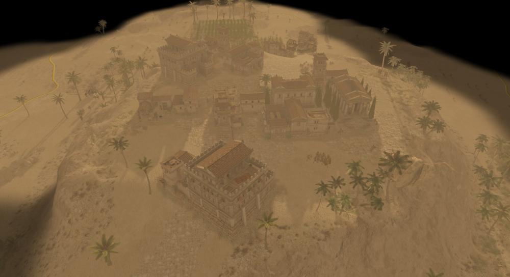
@wackyserious: Yes, it is exactly why I find this map fun to play It is also naval but not messy (because only 3 islands, and limited shores/docking options), very strategic because of the landform and the need of resources. You can also create several little cities on each island, then create markets and merchants traveling on your island. It is actually the first time I could make this important use of merchants, I don't really have the time or opportunity on other maps (it actually breaks the resource issue a bit too much to me, but then, targeting enemy's market and merchants is a very important strategy). About the environment settings: thanks for this tip. I am aware of these options, and already set the water (color and waviness, notably). But about the fog, it might be beautiful, but I avoid using it: it doesn't look so good and useful on my islands, and it tends to slow the map (it is quite big). I am afraid it induces lags on other computers too. I would like playability should be a priority over the nice look of the map. But I'll follow your advice and I'll try to make it better in the end.2 points
-
Needs some banners more military or some shields but isn't great thing. The building is very beautiful.2 points
-
Parallelization would indeed help, but it won't be feasible on such a small part as the pathfinder. Note that the pathfinder and unitmotion code has to be deterministic (needs to calculate the same path on all computers in a networked game). So if unit A and B both want to move to position (x,y) in the same turn, the pathfinder must have some preference (f.e. give the unit with the lowest id preference). When parallelizing it, there's no preference anymore, and it all depends on OS scheduling. Next to that, the pathfinder is also rather memory heavy (it has passability maps for different unit classes, and evaluating all nodes is also memory heavy). When parallelizing something, you have the problem that you need to copy a lot of data around to the different threads. So it's better to not do it on memory heavy. I see more promises in splitting off the AI to different threads (which already has a good separation of memory, so it can't modify the simulation directly but only by giving commands). Or the parallelization of not components of the game that don't have to be serialised. Like the 3D rendering, or the GUI rendering. @sarcoma, your memory issue is probably a valid bug, but one that's very hard to debug. We probably also still have some memory leaks, but it's hard to distinguish a small memory leak from valid increase in game data when the game becomes bigger.2 points
-
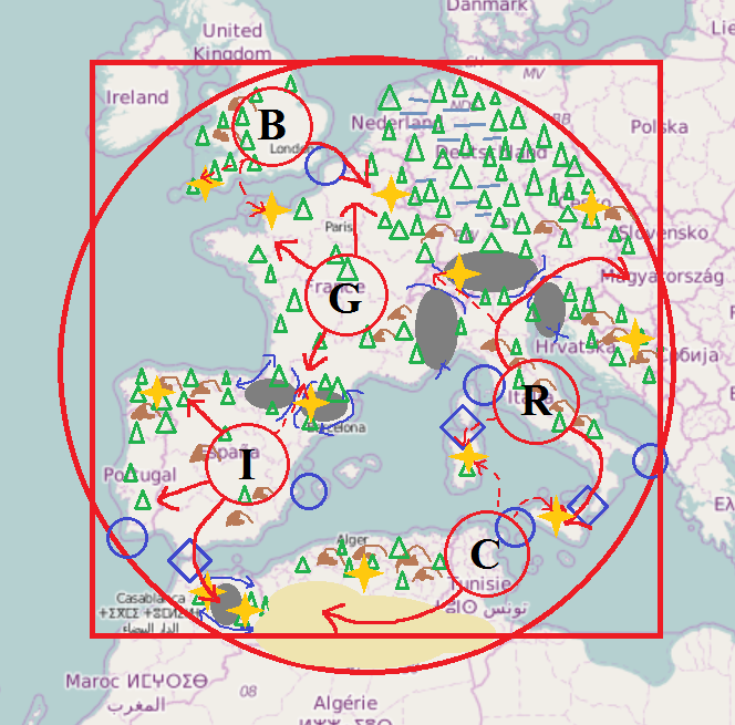
As AtlasMapper and I discussed in this thread, we want to create a new scenario map based on the civilizations and the real-world topography of the western Mediterranean. I did a simple sketch about what I have in mind so far, some explanations: blue circles: waterways passable only by ships blue diamonds: waterways both passable by land units and ships grey fields: impassable mountain areas brown symbols: passable hills blue lines: mountain passes and narrow ways around impassable terrain blue crosses: impassable shorelines yellow fields: desert (mainly found in North Africa) horizontal lines: swamp (mainly found in Germania) triangles: forests yellow stars: areas rich of resources (mainly mineral deposits, could also be stone or treasures...) red circles: initial territory of Britons, Carthaginians, Gauls, Iberians and Romans red arrows: primary expansion areas red dashed arrows: secondary expansion areas I think a circle shaped map is suited better than a squared map because the edges would contain quite uninteresting areas in the real world history of the used civilizations. The map should have maximum size (512x512). Regarding balance: Carthaginians, Iberians and Gauls have approximately the same amount of "natural territory" where they can expand to. This territory is protected by water or impassable mountain areas. Britons are quite limited in space, however, they can only be reached by ships making it very difficult to rush them and give them some defensive bonus. Romans do not have much free space around their initial territory, but they have the option to expand into a remote area and they can easily control the Adria, so fishing ships can be protected effectively. Iberians and especially Gauls are threatened from several sides giving them a strategic disadvantage. On the other side, they have the most options where they want to expand to and at least Iberians are protected by their initial walls. It may be necessary to also provide the Gauls with some extra defenses for otherwise help them a little bit. Mineral deposits should be distributed relatively equally over the map, preferably at strategic important places like mountain passes. Stone occurs a bit more often in the southern areas, especially in the desert. However, wood will be more present in the areas north of the Alps particularly forming the infamous Germanic forests between dangerous swamplands making the use of formations quite impossible. Edit: I'm just haunted by the idea to bundle this map with a small mod: it contains pirates, Germanic tribes and Greek colonies as three simple, non-playable factions (using existing models). Pirates and Germani are hostile to all players while Greek colonies are neutral (so trade is possible with them?). Some oak trees in the Germanic forests have a debuff aura affecting Roman soldiers, Carthaginian elephants do have bonuses against Romans, but Romans have bonuses against Carthaginian walls. Roman siege walls are stronger against Gauls which in turn can recruit a special druid at a settlement in Aremorica who gives all units in range OP stats against Romans... Ok let's finish dreams1 point
-
Well, i'm starting to make new animations for every type of unit in the game. It's a slow work so i'll be uploading every progress on the animation proposal. if something doesn't look good or can be improved please tell me, that's why i made this topic. FEMALE CITIZEN1 point
-
I suppose you are on A19. The path was changed on svn (and unfortunately the wiki was changed without refering that important point). So you have to look in ~/.config/0ad/logs/sim_log Concerning the AI error, I remember having fixed in svn some errors i had in attackPlan, so it may be that your bug will be already fixed when a20 is released.1 point
-
I am glad I am not the only one who has issues with the new capturing system. It's far too easy to capture, vs destroy. Attacking should be the primary function, not secondary to capturing. Fully garrisoned Iberian towers with 10 soldiers easily get swarmed and captured. In fact, I dislike the entire capture feature altogether and would like to see the ability to turn it off completely. Defending against siege weapons with units that I previously could easily defend with, is now next to impossible as they try and capture the siege weapons instead of simply destorying them. The entire game has just turned into a huge capture-fest.1 point
-
How about the shield and crossed spears on the side? That is a sure sign of a barracks. Most Hellenistic factions have that.1 point
-
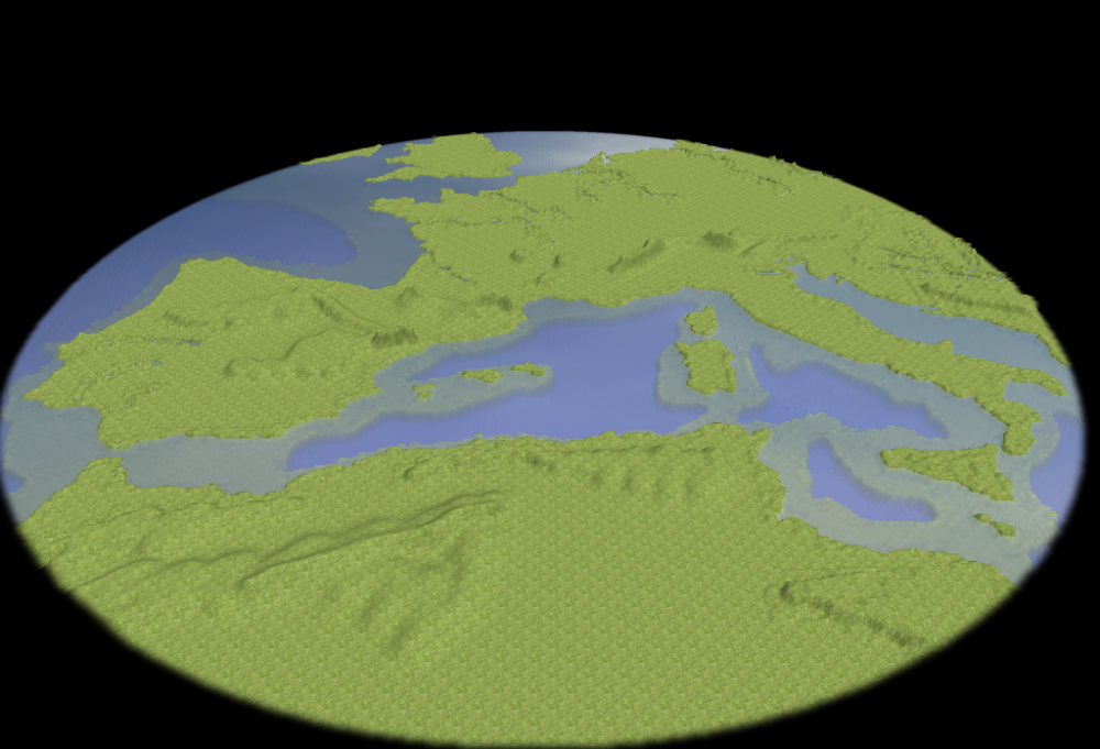
So here we go! The map will actually look like this (just a shore prototype, still need some work, especially with mountains): So it should cover the area you are expecting. Size 512x512. About your schema, it's a bit surprising to imagine land unit coming by feet from morocco to spain, or from sicilia to italia, but well, it is up to you. Actually, these areas are very close to each other as you can see on the screenshot, so it will be easy to set up. Anyway if such very small areas doesn't fit your need, you'll be able to adjust them very easily, even after the 3D model will be done: lowering only a few squares to allow land units to pass is really easy. But I'll try to do it by myself. About the mountains, I will draw them from real maps, so it will be some natural walls to units. I just have to set up the right height for them. But there should be more passages ways than you think, if we respect the reality (eg. units should be able to pass from italia to france by the south of the alps), but again, it might be easily modified to fit your gameplay needs, if you find it relevant. About the swamps/forests, you'll put them by yourself. Setting the whole netherland, north germany, and south denmark under the swamps it a little bit rude for these countries but again, if you find it fun, it's up to you. There will still be natural rivers there. It should be easy to expand them into swamps. As you can see, the 3D models (boths west and east) should be ready when you'll be back, in one month. I have some important recommendations, however: You'll obviously start by completing texturing. But then don't head directly to put units and buildings everywhere. Even if you have a scenario in mind (whatever if you plan to use triggers or not), first complete the map in a skirmish mode. What I mean is just some CC from each factions, to easily test the playability of the map. I'll put some on the 3D model, and I'll deliver the map as a skirmish. You'll need to add and balance the resources, forests, etc. This way, you'll see the features of the map, in term of relief especially, if you need to improve some road, block some access, etc. You can even simulate battles with AI only. This way you'll realy realize how the game will go on this map. If you put already units everywhere, you won't be able to easily see issues, and if they comes from the land, resources, or units. Modifying textures and land will be a pain, too. From the skirmish file, you'll be able to easily resave it as a copy and work on it as a scenario without any problem. That's an important advice I should tell, because I did make this error. Proceed step by step, you'll gain some time in the end. But for now, think about your thesis1 point
-
@AtlasMapper with this thread I officially accepted your offer I think let's just start with this one map, I probably won't be able to do anything before in a month or so. Terrain and some really basic texturing will be fine (I can do details afterwards and add all of the units, resources, trees etc.). Actually this will be my first 0 A.D. map, so probably I will need a bit longer and ask for feedback. What is quite important to me is the (non-)passability of the grey mountains and the water streets I marked with blue circles and diamonds. If you disagree, then let's discuss this together. Multiple AI are not really a big problem for me (it becomes laggy though with 1000+ units on the map). I understand your point of view on the scaling between real world and maps. If you want to replay realistic battles in real-time you are right. The Total War series must be appealing to you then. The game on a map like this however is more like a miniature simulation. Thousands of kilometers are reduced to a few hundred meters, hundreds years of history are condensed to an hour, millions of humans are reduced to a few hundred, many thousand buildings reduced to some dozens. Of course this leads to many simplifications, but with some imagination you can have the feeling to "write history", conquer whole countries instead of taking a single settlement or fighting a small army...1 point
-
Just come on our #0ad-dev IRC channel, and someone will probably answer (the channel is mostly active during European evening though).1 point
-
It may be more important to show the dummies, anvils, shields, spears, etc., than to give the men some shade. I mean for gameplay (need to make it clear what this building is quickly). But LordGood is proficient artist. He can decide.1 point
-
This looks like a nice map to play once it is finished! I've always wanted to play in maps like this, maps with clear choke points and interesting landforms. In the final stages of dev. you can also try to tweak the settings in the Atlas environment tab (Sun settings, terrain/object ambient color, water color, fog, etc.)1 point
-
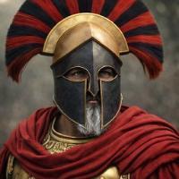
Nice references lion, I hope the previous helmets will get in the game soon. The cataphract helmet is in though...1 point
-
I made a horse animation sometime, but every animal has their own moves and references. It's a little bit dificult, depends on the animal but nothing that i can't learn in a couple of days And yes, maybe the walk move it's too much exagerated. But that's why i made this topic, any advice will be apreciated1 point


.thumb.png.ce58cea22940c255f5b0a735d5abee36.png)


