Palaxin
Community Members-
Posts
217 -
Joined
-
Last visited
-
Days Won
2
Everything posted by Palaxin
-
LOL Ok, that's true, but heavily depends on the situation. If the map is open and/or games do not extent quite long (to a point where you are stockpiling resources), champs will only be attractive for certain civs with special bonuses/upgrades like Britons, Spartans and Macedonians. IMO a more natural approach would be to increase building armor and/or HP with techs (e.g. improved building materials and architectural advancements) in town and city phase. Shouldn't be expensive though, so you can expect to research them soon.
-
[Scenario] Western Mediterranean (5)
Palaxin replied to Palaxin's topic in Scenario Design/Map making
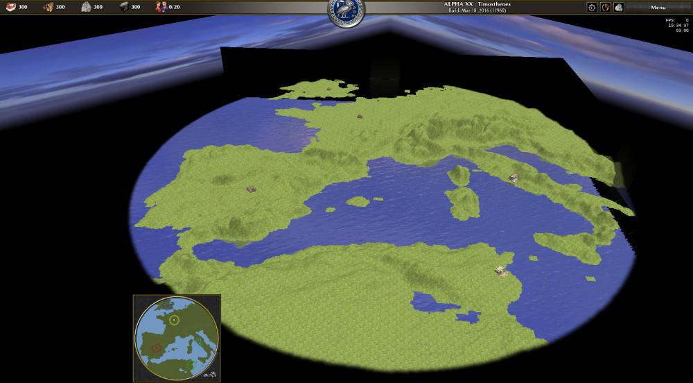
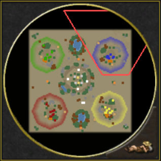
So today I was playing around with the heightmap tool, I was just curious, and got this result: However, some things are bothering me: The map edges are not updated with the heightmap data, there are always two borders like giant walls (you can see them as black rectangles in the picture). I first tried a 512x512 heightmap, then 513x513, but nothing changed. I haven't heard of this bug before, does anyone have? I couldn't find a good heightmap which includes both ocean and land height data, so currently the ocean is just super flat (I therefore added extreme murkiness). @AtlasMapper which source did you use? BTW you did good work and I currently don't intend to replace it, I'm just curious at the moment In Atlas there seems to be no possibility to get square maps instead of circle maps. -
Make AI Settings visible to players (small suggestion)
Palaxin replied to av93's topic in General Discussion
@Lion.Kanzen Nice, I would love this! -
Welcome, @borg- I think @scythetwirler's intention is to use soldiers mainly for capturing and siege for destroying. You probably noticed that siege and elephants have been buffed, so they are a lot more effective against buildings now. I agree that the champion nerf may be exaggerated a bit. Increasing the train time was necessary, but the additional increase in cost AND the decrease in armor can easily make them less cost efficient than citizen soldiers (certainly if they are ranked up). In my opinion it is good and realistic (swords would be blunt/useless soon if hit too often on a stone wall) to make buildings less vulnerable to soldiers, however I propose to add the possibility to burn (wooden) buildings. This way some units would be useful beyond capturing and you would have more strategic possibilities without breaking realism. If you still want to destroy structures easily with your soldiers, just edit the armor values of some building templates in binaries/data/mods/public/simulation/templates. Could be a small mod
-
Make AI Settings visible to players (small suggestion)
Palaxin replied to av93's topic in General Discussion
I like this idea in the current implementation. However, if we added different AI characters like Aggressive, Defensive, Economy etc. (not sure if this is planned) I would still prefer a dropdown list instead of Petra Bot (Hard, Economy) or Petra Bot (Hard) (Economy). -
Yesterday I was introducing my friends to 0 A.D. and we did some multiplayer games via LAN connection. They were thinking similarly: nice overall impression, but they immediately noticed the 500 ms turn length. We were three human players and no AI and there was nearly no lag at all, so I agree to reduce turn length at least for LAN connections. Apparently other games manage to be more fluent, even when played over the internet. For example in League of Legends reactions are so crucial that similar turn lengths would totally destroy the game. However they use separate servers for each (part of a) continent so this should help with this problem indeed. Taking only physical properties into account (the very hard limit for connections of all type), a signal travelling in a cable needs about 100 ms to cross half the globe (the longest possible distance on earth surface) and about 67 ms if it propagates as an electromagnetic wave through the air. Double the values for client → server → client. Of course you can't assume that the signals travel directly and each device has to process the information so it adds additional delay.
-
Of course a good balance needs to be found. In Stronghold fire spreading was definitely way too fast. I thought we could adjust it so the next building catches fire after perhaps 15 seconds. You would have plenty time to react then... Another way to limit the impact is that buildings stop burning after some time (after researching a certain tech for example) or to allow citizen soldiers to save your buildings with water buckets (would replace the repair command for burning structures). I think it should be possible to erase the fire with 10-15 units before it can take over other buildings.
-
I don't want to go too far off-topic, so I made a proposal here. Probably it's not too difficult for the devs to implement this.
-
I proposed a burning mechanism here and added some ideas for balancing here. This would make warfare more realistic and especially burning projectiles could benefit from it. You would also have to be more cautious when placing your (wooden) buildings. We could introduce e.g. the following xml-tags in the structure templates: <Burning> <isFlammable>boolean</isFlammable> <burnRadius>positiveDecimal</burnRadius> <igniteRadius>Decimal</igniteRadius> <igniteHpRatio>positiveDecimal</igniteHpRatio> <igniteDelay>nonNegativeInteger</igniteDelay> <burnDamage>nonNegativeDecimal</burnDamage> <canBeStopped>boolean</canBeStopped> <maxBurnTime>nonNegativeInteger</maxBurnTime> </Burning> isFlammable: When set to true, the structure can take fire. burnRadius: Radius of the area which is affected by the "fire aura". Units in this area will take fire damage. igniteRadius: Is added to the burnRadius in order to determine if the building can catch fire from another building in the vicinity. Tough buildings have negative values (so they need to be very close to the fire) while buildings with e.g. straw roofs have positive values (can be ignited easily with e.g. sparks even from a distance). igniteHpRatio: Must be >0 and <=1. If the building's igniteHpRatio >= currentHp/maxHp it can be ignited, otherwise it must take further damage from other sources before it can catch fire. igniteDelay: Number of milliseconds all other burning conditions have to be met in order to set the building on fire. burnDamage: Number of HP the building loses per second while on fire. canBeStopped: Determines if the burning can be stopped by external events like rain weather (perhaps implemented in the future) or by citizen soldiers using a "fire brigade" command (replaces repairing for structures on fire). maxBurnTime: Number of milliseconds after which the building stops burning automatically. If set to 0, the building will burn until it is destroyed. Of course we could simplify the mechanism and leave out some tags, so all buildings share a certain default value.
-
I think a burning mechanism similar to the one in Stronghold Crusader would be a nice addition to the game. Fire (causing damage over time) should spread between wooden structures placed closely together. As a consequence, you would have to be much more careful when planning your city...
-
Since the white rhino as well as the Indian rhino are included in the official tasks I propose to call the current template fauna_rhino_white instead of fauna_rhino. So we can distinguish the current rhino from the future fauna_rhino_indian. If you are Ok with this proposal, I can make a patch. IMO the size of the white rhino model is also too small especially compared to the giraffe, as you can see here. According to Wikipedia, the white rhino weighs about 2000 kg (average of males and females), giraffes only about 1000 kg. The North African elephant was probably similar in size with the African forest elephant, weighing about 2700 kg, so it is nearly comparable with the white rhino. I propose to increase the model size of the rhino, and decrease giraffes a bit. Also the proportions between camel and horse are not fitting together. Both animals have about the same weight, however their models have big differences in size as you can see in the linked picture (which shows all animals arranged to their real life weights, references can be found here). I have no experiences with 3D art, so I've no clue how much work it requires to rescale the models and if this somehow affects the animations and other parts. If you can explain me why the current model sizes have been chosen or why my references are bad, please let me know. It would help me with my work on balancing animal stats (see ticket 3778).
-
[Scenario] Western Mediterranean (5)
Palaxin replied to Palaxin's topic in Scenario Design/Map making
@AtlasMapper Sorry for my impatience! Looks much better already Go on with the good work, I believe you that height map import is complex. @wowgetoffyourcellphone Go on! We could also work together on this map... -
[Scenario] Western Mediterranean (5)
Palaxin replied to Palaxin's topic in Scenario Design/Map making
AtlasMapper, thank you very much for your help! You offered to also model the eastern Mediterranean, but please only do that if you have nothing else to do, since I'm not sure if I want to work on two maps or turn to another project after this one. My first impressions on the raw map: Regarding the chosen map section, the North African part seems a bit too huge for me. This is partly due to the perspective, but I still think it could be a little bit smaller. The water passages at the Iberian west cape and Italian east cape are very narrow, can ships pass them? I think this is a minor problem because we can widen them a bit if necessary (reducing the perfect match to real-world land shapes a bit). The heights occur in certain steps like terraces - this is probably due to the limited resolution of the heightmap and can't be changed, right? The geography of mountains and hills seems to be quite simplified. The Italian Apennines are lacking completely, the Alps are much wider in reality, and together with the Pyrenees they should stood out a bit more in height compared to some other areas. Probably this is due to the step simplification. But you could try to increase the height range (I would say a factor 2 is not too much), so the mentioned lack of detail should become less obvious. If the slopes are too step then they can still be smoothed afterwards. I think the Strait of Gibraltar (Spain and Morocco), the Strait of Messina (Italy mainland and Sicilia) and the Strait of Bonifacio (Corsica and Sicilia) should be passable by foot units because they are so narrow in reality that transportation seems to be very quick (which could be simplified in the game to the extend that they can be passed directly). I also wanted this to allow Hannibal his famous march over land (and not directly ship to Rome). The same reason is why I made only two passes in the Alps (he should not walk at the beach, but high in the mountains). Actually I'm sure forcing gameplay that way won't work in most cases, but as you said I can do little adjustments by myself if needed. I will surely flatten the beach at most points since I don't like this terrace-like style. Yes I will do the swamps and I'm actually German myself, so I should be allowed to place them in my country And I will only place them according to the best knowledge of real world topography at that time, so they might be reduced after some research. I don't want to be rude to the people living there! Thank you for your tips regarding scenario and skirmish mode! I wasn't thinking about that Have fun with map making, also with your island scenarios! Finally you don't have to stick 100% to my sketch, if you think that some feature doesn't make sense just skip/change it and I can think of it afterwards. -
[Scenario] Western Mediterranean (5)
Palaxin replied to Palaxin's topic in Scenario Design/Map making
Yes, I therefore propose to import a heightmap into Atlas and edit the terrain based on that. IIRC AtlasMapper has already experience with that tool... -
I already switched to this thread... Perhaps we should have done that earlier
-
[Scenario] Western Mediterranean (5)
Palaxin replied to Palaxin's topic in Scenario Design/Map making
@AtlasMapper with this thread I officially accepted your offer I think let's just start with this one map, I probably won't be able to do anything before in a month or so. Terrain and some really basic texturing will be fine (I can do details afterwards and add all of the units, resources, trees etc.). Actually this will be my first 0 A.D. map, so probably I will need a bit longer and ask for feedback. What is quite important to me is the (non-)passability of the grey mountains and the water streets I marked with blue circles and diamonds. If you disagree, then let's discuss this together. Multiple AI are not really a big problem for me (it becomes laggy though with 1000+ units on the map). I understand your point of view on the scaling between real world and maps. If you want to replay realistic battles in real-time you are right. The Total War series must be appealing to you then. The game on a map like this however is more like a miniature simulation. Thousands of kilometers are reduced to a few hundred meters, hundreds years of history are condensed to an hour, millions of humans are reduced to a few hundred, many thousand buildings reduced to some dozens. Of course this leads to many simplifications, but with some imagination you can have the feeling to "write history", conquer whole countries instead of taking a single settlement or fighting a small army... -
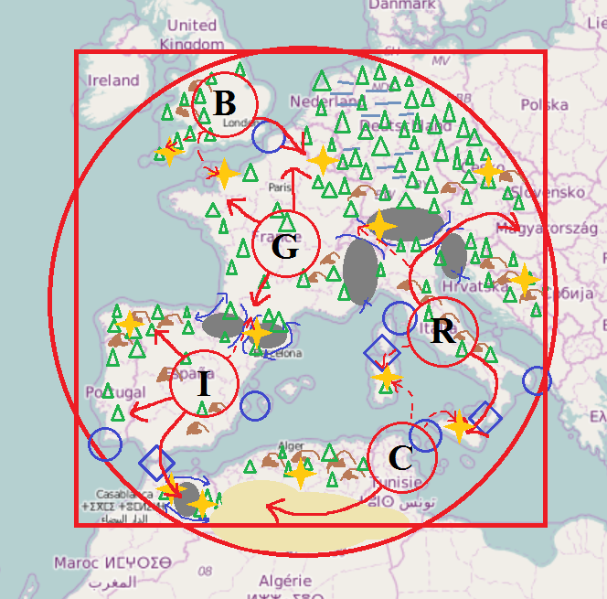
As AtlasMapper and I discussed in this thread, we want to create a new scenario map based on the civilizations and the real-world topography of the western Mediterranean. I did a simple sketch about what I have in mind so far, some explanations: blue circles: waterways passable only by ships blue diamonds: waterways both passable by land units and ships grey fields: impassable mountain areas brown symbols: passable hills blue lines: mountain passes and narrow ways around impassable terrain blue crosses: impassable shorelines yellow fields: desert (mainly found in North Africa) horizontal lines: swamp (mainly found in Germania) triangles: forests yellow stars: areas rich of resources (mainly mineral deposits, could also be stone or treasures...) red circles: initial territory of Britons, Carthaginians, Gauls, Iberians and Romans red arrows: primary expansion areas red dashed arrows: secondary expansion areas I think a circle shaped map is suited better than a squared map because the edges would contain quite uninteresting areas in the real world history of the used civilizations. The map should have maximum size (512x512). Regarding balance: Carthaginians, Iberians and Gauls have approximately the same amount of "natural territory" where they can expand to. This territory is protected by water or impassable mountain areas. Britons are quite limited in space, however, they can only be reached by ships making it very difficult to rush them and give them some defensive bonus. Romans do not have much free space around their initial territory, but they have the option to expand into a remote area and they can easily control the Adria, so fishing ships can be protected effectively. Iberians and especially Gauls are threatened from several sides giving them a strategic disadvantage. On the other side, they have the most options where they want to expand to and at least Iberians are protected by their initial walls. It may be necessary to also provide the Gauls with some extra defenses for otherwise help them a little bit. Mineral deposits should be distributed relatively equally over the map, preferably at strategic important places like mountain passes. Stone occurs a bit more often in the southern areas, especially in the desert. However, wood will be more present in the areas north of the Alps particularly forming the infamous Germanic forests between dangerous swamplands making the use of formations quite impossible. Edit: I'm just haunted by the idea to bundle this map with a small mod: it contains pirates, Germanic tribes and Greek colonies as three simple, non-playable factions (using existing models). Pirates and Germani are hostile to all players while Greek colonies are neutral (so trade is possible with them?). Some oak trees in the Germanic forests have a debuff aura affecting Roman soldiers, Carthaginian elephants do have bonuses against Romans, but Romans have bonuses against Carthaginian walls. Roman siege walls are stronger against Gauls which in turn can recruit a special druid at a settlement in Aremorica who gives all units in range OP stats against Romans... Ok let's finish dreams
-
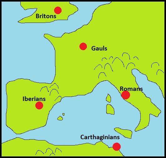
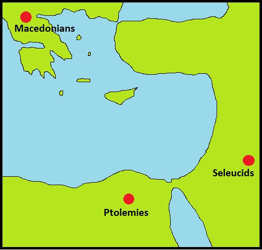
Yes, I agree with you that it is incredibly helpful to get feedback from other people. I guess many of us (including myself) simply prefer working on own ideas rather than testing for others since we are all volunteers and only have limited time available. But I can test your map when I have finished my Bachelor thesis in about two weeks I'm afraid I can't give you the best advice regarding resource balancing, I still have to figure out similar questions for my mod. Probably the best advice can be given from experienced players (I'm not playing often), perhaps you can try to find someone in the multiplayer lobby? For technical questions IRC is the way to go, but you have to be lucky to get quick answers there. Regarding the maps, I had something like that in mind (lol my Paint skills and geography knowledge are not that bad than I thought): So the maps are not focused on some little battle area but rather include the whole settlement areas of the different civilizations. You could either let the players do what they want to rewrite "history" or use some triggers etc. to force specific actions. As far as I know triggers are not in their final stage and I haven't tried them out... If I will find time to go into mapping I probably will try to work on better random map terrain with simplex noise. I really love real-world maps but I fear I'm not patient enough to create them. But if you have more fun creating pure islands maps, do so! The map of ancient Greece is perhaps my favourite one, but I think it would still be nice to zoom out and include the Near East and the Nile delta, so Ptolemies, Seleucids and Persians can have their homes, too Edit: I also saw your other maps, they look all very promising! As I said time is scarce and I can't try everything...
-
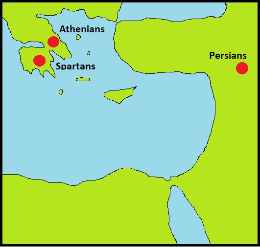
AtlasMapper, your maps look great and personally I think one can never have enough real-world maps... The thing is you can't really expect people to extensively test your maps, I also did this more or less for my mod which has the goal to replace the generic ore with iron, copper etc. (still gathering "metal", but different gathering speeds) to make resource collection more interesting. But in the end it's mainly up to you to do the testing... I see with Aeolian Islands you also try to make resources have a bigger impact on gameplay, so I appreciate this map very much If you are still looking for a future project on real-world mapping I have two proposals (I'm not really experienced in mapping, so I'm sure these maps would look much better if made by you): Scenario map of the western Mediterranean: includes Iberians, Gauls, Romans and Carthaginians (probably Britons are out of range) Scenario map of the eastern Mediterranean: includes either Macedonians, Seleucids and Ptolemies or Athenians/Spartans and Persians (think of the Battle of Thermopylae...)
-
Since we have a couple of new maps, I agree to use a name with reference to that. Terra (Marique) and Timosthenes sound both good to me...
-
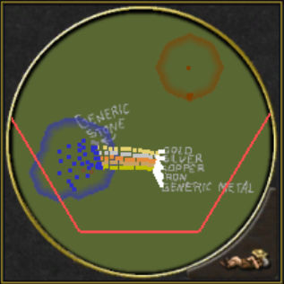
you can see the mini map colors of the ores best in the upper left picture of the demo map (gold, silver, copper, iron, current ore from top to bottom)
-
MinMod version 0.2 with random map support released! download at my first post Thank you for your feedback on the previous version! I included some suggestions: Karamel: ores should only differ in gather rate, but not in size / resource amount av93: ores should differ more from stone; I added copper sparkles and slightly colored the ore textures according to the respective metal About the gameplay proposal to only include two different ore types: most random maps only use iron and silver ores. Copper with the standard gather rate is used where it is difficult to introduce two ore types. Gold is reserved for skirmish and scenario maps where it can be placed carefully and mark places of special importance. So random maps use 2 ore types on average and skirmish/scenario maps 3 types. Let me know if you have any problems or further suggestions
-
code for tech and aura modifications
Palaxin replied to Palaxin's topic in Game Development & Technical Discussion
I think I finally found it in globalscripts/Technologies.js if (modification.multiply) retValue += (modification.multiply - 1) * propertyValue; else if (modification.add) retValue += modification.add; else if (modification.replace !== undefined) // This will depend on ordering because there is no choice retValue = modification.replace; -
Not sure if this is the right subforum (perhaps the mod subforum is suited better). AFAIK currently techs allow the modifications "add", "multiply" and "replace" and auras "add" and "multiply". The problem with "multiply" for techs is that it is calculated on base stats, not on current stats (as I explained here). I would like to differentiate between e.g. "multiply-base" and "multiply-current", but either I couldn't find the right place in the code or I'm a bigger noob than I thought. I looked in simulation/components/TechnologyManager.js and simulation/helpers/ValueModification.js as well as some C++ source files, but couldn't find similar code like this (taken from AuraManager.js): if (data.add) cache.get(classes).get(key).add += data.add; if (data.multiply) cache.get(classes).get(key).multiply *= data.multiply; My C++ and JS skills are quite limited but I would try to change the multiply operation for technologies if I knew where to look for it...
-
Just wanted to remind that we may start looking for a name begging with "T" for the next alpha release...


