

Scallact
-
Posts
37 -
Joined
-
Last visited
Scallact's Achievements
")
Discens (2/14)
26
Reputation
-
Congratulations and a big Thank You to the team!!! Can't wait to try this new version with all the features and improvements!!!
-
Well, maybe that the elephant in the room, while we are talking about everything else? I understand the perfectionism of the devs, in not labelling the game as "finished". However nowadays nothing in the market is ever finished. Or maybe it's a dev's choice, to limit unavoidable player's pressure by a too large community? Which I would understand as well. But, from a player's perspective, it's a lot of wasted awareness potential.
-
heightmap import improvement
Scallact replied to viridis's topic in Game Development & Technical Discussion
A temporary solution I found, useful if you are not confident with copy-pasting into a hex editor, is with a nice little command line utility: Swiss File Knife. It's multiplatform, and doesn't even require an installation. Just put the executable near your files and run it in a terminal. The useful command it provides is "partcopy", which allows to copy part of a binary file to another. An example command, to transfer elevation from a 385x385 uncompressed 16 bits greyscale .tif to a large .pmp : ./sfk partcopy [source_name].tif 8 296450 [map_name].pmp 16 -yes The number in the middle is the number of bytes. It must be adapted to the map's size: map size tif(px) bytes ----------------------------- normal 257 132098 medium 321 206082 large 385 296450 very large 449 403202 giant 513 526338 -
heightmap import improvement
Scallact replied to viridis's topic in Game Development & Technical Discussion
Yes !!! We need that ! 16 bits import ability is the only missing link between elevation files and the Atlas. I have a GIMP plugin nearly ready, for the creation of elevation files, but I'm hesitant to publish since the import learning curve is too high. Your idea of a GIMP plugin for .pmp export is nice too, that would perfectly fill the gap. Before anyone asks, I don't think I would be able to write such a plugin with my current python level. :-) I might still try to look at it in the (not near) future if nothing moves on this front. -
Alpha 26: Atlas terrain texture previews fix
Scallact replied to vladislavbelov's topic in Announcements / News
All good now! Thanks!!! -
Alpha 26: Atlas terrain texture previews fix
Scallact replied to vladislavbelov's topic in Announcements / News
Thanks a lot! There are still many blurry textures on my side, for example, the majority of "Biome Alpine", and many others. Alpha 26 final on Ubuntu Linux 20.04, the snap version and the ppa version have the same problem. -
You surely meant "wood" instead of "food"? Too bad you didn't bring it up during the long release candidate testing? Like, it seems no one tested the Atlas during that phase, and now all textures are just a single color in the interface. (I'm a culprit too)
-
Oh ok, thanks for the info! Will try another civ tonight.
-
Why aren't Athenian and Persian included in the changeset? Don't these civs benefit of the new tracks? I played with the Athenian last night, and I only heard the old tracks, even when watching the replay.
-
Preview of a GIMP plugin for procedural heightmaps
Scallact replied to Scallact's topic in Scenario Design/Map making
That would be huge! -
Preview of a GIMP plugin for procedural heightmaps
Scallact replied to Scallact's topic in Scenario Design/Map making
So we are back to the "external software - mesh import" model. Which is exactly what I do with my plugin. You know what would be extremely useful ? An Atlas mesh import function which doesn't crush the heightmaps to 8bits. :-) -
Preview of a GIMP plugin for procedural heightmaps
Scallact replied to Scallact's topic in Scenario Design/Map making
@smileyHere is a height-map produced with the "distance map" algorithm. Those mountains are too huge but it gives you an idea.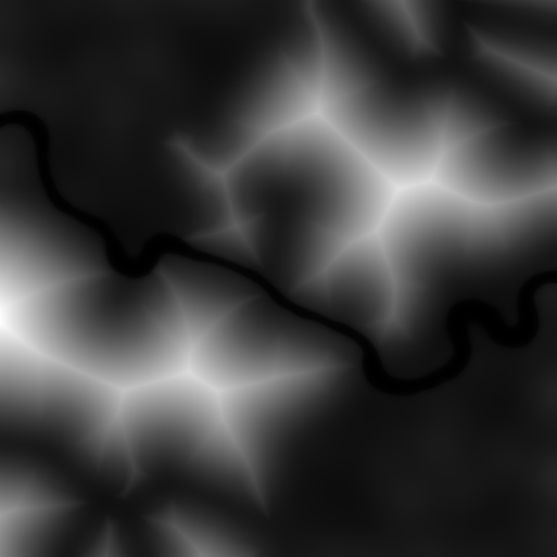
-
Preview of a GIMP plugin for procedural heightmaps
Scallact replied to Scallact's topic in Scenario Design/Map making
Pardon my ignorance - what is an "actor mesh" ? -
Preview of a GIMP plugin for procedural heightmaps
Scallact replied to Scallact's topic in Scenario Design/Map making
If you're looking for some simpler algorithm, I also made experiments with the "Distance map" one. Gives some nice, if not slightly "too regular" results. Maybe that would fit your requirements. Basically, it computes for each pixel the distance to the nearest black pixel. This give cute mountains with constant slope. -
Preview of a GIMP plugin for procedural heightmaps
Scallact replied to Scallact's topic in Scenario Design/Map making
See above! TL;DR : yes, I use some advanced image processing algorithms ! ;-) At least, the "Solidify" G'Mic algorithm is the basic concept of it all.

