
Garaf
-
Posts
35 -
Joined
-
Last visited
-
Days Won
2
Posts posted by Garaf
-
-
Hi, @Palaxin
Is already an excellent guide
") , I quickly posted that data for two reasons:
, I quickly posted that data for two reasons:
- - From the Main Page also get access to a Research Database, where data collection is very rich, has a choice that ranges from 1 to 3 and 15 seconds of arc, one that I linked has some areas of Europe with precision a second of arc.
- - With GDAL I saw that the data can be extracted with various parameters, but I have not studied further, and more - this could be of interest to programmers - it has a variety of cross-platform API to use and open source, but I do not know how to use them Atlas; It is used in several GIS systems and for the construction of maps in 3D.
When I have a little time on their hands to see further data extraction and various export formats, I also see for bathymetric.
Keep in mind that the test I made was "on the fly" and not to make too harsh heights have limited the range of gray (256) to a number of 52 starting with 2: 2: 2 to 54:54:54 at the time extraction in Tiff.
I made a scaling, and this is the result first test in the mountains where I live and which I know well:Spoiler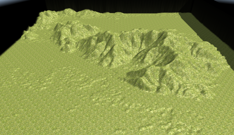
These are the files used (Including those of Atlas): Files Serra.zip
I just tidying things ... will let you know, I think if we can make it as easy as possible the creation of maps close to the real, many will be even more interested in the game and participate in the development") .
.
Greetings to all, good job and have fun.-
 2
2
-
2 hours ago, Palaxin said:
Hm... or toggle steady recalculations either with a simple checkbox in the GUI or automatically when the obstruction overlay is active. BTW how can I make the overlay visible in Atlas (like in the spoiler images here)?
@Palaxin In the Tab "Terrain" of atlas you can switch in the passability drop-choose of visulization.
By the way I found these indications:
Using real world data "DEM files" to generate 3D maps
And is good this related link for downloading maps DEM and I did some tests.
To remedy that you indicate in the first post I modified relief.clr file using GDAL as indicated in the forum to limit the heights in the transformation in Tiff in this way:
100% 55:55:55
0%   2:2:2
nv   0:0:0
Once exported to Tiff opening it in GIMP can be further improved.This is the result:
Spoiler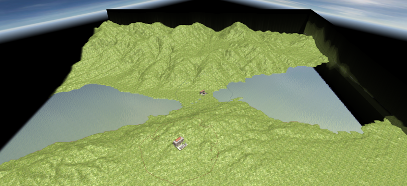
Rather, there is a fast way to remove the error on both sides or is it a bug-
1
-
-
I am the copyright holder of original works I post in the Wildfire Games 0 A.D. Art Development forum. I hereby release all original works I uploaded to this forum in the past, and those I will upload in the future, under the Creative Commons Attribution-Share Alike 3.0 Unported license.
-
1
-
-
On 18/4/2016 at 10:49 PM, Lion.Kanzen said:
......
http://teutalingonescinghialebianco.forumfree.it/?t=49144501
is in Italian but looks useful. is a word reference from Celtic lang.
I saw now the message of 18/4, the link was given a part of this site:
http://www.melegnano.net/spie0006e0.htm
I do not know if everything is correct, speak of a Celtic - cisalpino to Italian.
I think it is a root of Insubria language which, in turn, has influenced Latin-
1
-
-
8 hours ago, feneur said:
To delete/move actors, press the Alt key and then select etc as usual.
Thanks @feneur, I tried but I only allows the rotation, I can not move, and delete.

So I remove manually from the XML file, but is... too long .
hmmm ... maybe something in Ubuntu configurations for window management ... I'll check and reboot the system.
See you laterBingo!
I do not know if it can affect everyone, but certainly those who use Kubuntu.
To interact with the windows the expected default button to be used with the mouse is ALT, but there is the possibility to change it with META.
This is done ... it all works.
Thanks for the flea in the ear Feneur -
8 hours ago, sanderd17 said:
Nice graphics IMO, though the trees are placed in quite a strange pattern. Normally, trees appear in bushes, or are manually placed along a road. They're not placed that evenly, and the amount of different trees that mix together well is normally quite limited either (a certain tree tends to grow better on a certain ground, and will outgrow the other species there).
Also, the map is quite unbalanced, but I guess that's not what you were trying to achieve.
Thanks Sander for notes.
I agree with you for the location of the trees, I had too much in a hurry to close the graphic part to test the fighting.
I had the desire to change the biomes, with this your note I put it as a necessary first step.
I mean for the balance in more detail.The territory
The areas used by factions are arranged following these criteria.
The position of the besieged and the besiegers, must be facing each other.
The besieged can not have too much room for maneuver and expansion as their fate depends on whether or not the arrival of the aid, can only make prolong the siege but not that much.
The Pontii must at the same time maintaining the siege and expand on the heights above to have short connections to the siege walls.
The Romans can only expand into two plateaus and can only use the narrow valley to descend towards the city, the underlying part are affordable, and in part, only from below.Resources
I have already alluded in the first post.
The besieged it difficult to get out, so I do not have many and can not have, except those provided food and wood, they are forced to use the trade.
The Pontii have had time to organize a quarry in the hills from where they extract stone and metal.
The Romans having just arrived, still have to organize themselves completely, but have little time, otherwise the ally falls.
Number of fighters already there.
The amount and location I chose doing some tests, in this case the problem is subjective as it depends on combat tactics that a player adopts.
So far I have only compared with the AI and I miss seeing other tactics used by human.
If you mean another for the balance I ask you, please, to make me understand better.
If I can I would like to ask a question, how come the Entities once placed are manageable with the Atlas while the Actors no, it's one of the things that made me lose time with the trees and I concluded quickly.
Thank you for now and greetings -
Hello everyone.
I wanted to try a scenario related to a battle.
I've chosen a city, Cyzicus, who has lived many (in 410, 73 B.C., in the 193, 672 and 1305 A.D.)
The last was a clash between the army of the Roman Republic, Commanded by Lucius Licinius Lucullus, and That of Mithridates VI of Pontus, fought in 74-73 BC near the city of Cyzicus, besieged for a year by the Pontic forces. Lucullus liberated the city and destroyed the enemy army. The battle was an episode of the Third Mithridatic War.
The town lies at the center of the Sea of Marmara, at that time called Propontis.
I used as starting a map of the battle hypothetically reconstructed:
MapOrography
I turned the map in gray scale, cropped, added more levels of gray, blurred to decrease some slopes and imported into Atlas.
Immediately after the import I saved and I modified the XML giving "false" to CircularMap (if you gave after the mistake was taking on local calculation).
I fix it by hand the two high walls that are formed on both sides of the map.
I've changed the sea level gradually to give different textures depending on the depth, then returning it to the original.
I used passability> Building-land / Building-shore to affix the rock textures and end sand textures.Constraints
The city is under the protection of Rome but has Greek origins and culture.
The city is fully developed but under siege, the cultivated fields are dangerously close to the besieged walls of Pontii.
Few resources, limited the expansion of the presence of many objects (trees, fences, walls) are present fish.
It can be used on the market and the port for commerce and increase resources.
He has already provided some high-ranking warriors for the defense.Mithridates has been present for a year, has already opened a quarry of building material and metal.
It has already built a siege wall and some buildings so does not have many resources readily available.
It also has a port and if it has a market can start businesses there are fish.
It has already provided a minimal impact force for the siege.Locullo arrived recently, has established the camp in the vicinity of some resources and began making the first constructions.
In the tents has a contingent of high-ranking warriors for intervention.
He has already disposed of the guard posts along the way but they go quickly manned.Hope you like, it is at your disposal
Questions and criticisms are well accepted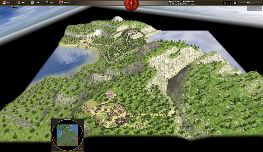
Greetings and have fun, now I have to go out, we read in the evening (CET Italy)
-
3
-
-
On 6/5/2016 at 0:49 PM, LordGood said:
Though gravity should remain constant, it would help simulate wind resistance if there was a play to it on different projectiles, I would think. Since there are no other possible forces acting on projectiles other than starting velocity and trajectory
This is very correct.
Note that the drag in a fluid such as air is dependent on the square of the speed:
R (kg) = 1/2 Cr "ro" S V2So, if the wind is 5 m/s and R=50 with 10 m/s > R = 200
If i remember my old study
(congratulations for the animation)
-
1
-
-
A greeting and I hope to be welcome.
Italy at that time was rich in metals, and agriculture.
The mining part of the peninsula used by the Etruscans and then by the Romans was the Maremma.
The first Etruscan mines were on the island of Elba and in Gavorrano (Pyrite).
The climate was different than now, was the "Roman Warm Period."
The second was the "Medieval Warm Period"
Only when Rome expanded much had the need to use the fertile plains of northern Africa.
They arose in that period several Castrum to defend the barns now called Tunisia Algeria and Libya KSAR which derives from the Latin Castrum.
From KSAR result, the words ALKA'ZAR in Spanish, Portuguese ALCA'CER, and CASSERO in modern Italian
The granary of the empire was for many years the north africa.
The beginning of Rome, moreover, came with the League of farms on the Tiber.
Throughout Italy there are old remains of farms Republican expansionary period.
For the stone the areas used were for the TIVOLI Travertine, the Apennines to the sandstone; Lazio was an open quarry of tufa and pozzolana to mix the burnt lime to make the first concrete.On this occasion I congratulate you for the work you are doing with the historical tuning of the game.
PS. Sorry for my English

-
3
-

Buildings portrait process and little theory
in Eyecandy, custom projects and misc.
Posted
@Lion.Kanzen Keep in mind also that in the assessments:
https://sites.google.com/site/famigliaomo20/i-lari-e-i-penati
There is the English translation after the Italian.