

mimesot
-
Posts
34 -
Joined
-
Last visited
-
Days Won
1
Posts posted by mimesot
-
-
2 hours ago, LordGood said:
The detail in this map is gorgeous
Just a word of warning, the Ptolemies and Athenians may see a change in art direction in the future. Native structures should still be available in the scenario editor, but it'll take a little bit of rebuilding if you continue developing this map
Thanks a lot!
I'm always glad to see that 0 a.d. evolves, and so will my map.
Of course this rises a few questions: What happens if an entity is no longer available in the map editor? Is the map going to load or crash? Will there be some kind of dummy-entity, which replaces all obsolete entities of will it leave void spots? Will all current entities still be present after these changes, with just their visual representation altered?
Greeting
mimesot -
Hi!
26 minutes ago, Nescio said:Is the Nile shallow enough for units to cross it on foot at any spot, without needing any transport ships? If not, the map will effectively consist of a few unequal islands.
Yes, the Nile has 6 shallow areas where you can cross it. As you said, if the parts of the map would be islands, this would be very difficult to balance. Their main purpose of the positioning of the shallow spots is to direct the flow of units across the map. The placement was particularly intended to provide three things: 1) To elongate the distance between Alexandria, Siani and Memphis as their starting positions are so close. This is of course irrelevant for the 1 vs. 1 version of the map, but it could potentially become even an 8 player map. 2) To reduce the advantage of the north-south riverbank route regarding long distance travel time in comparison to the routes via eastern and western desert. 3) To make the the route from river Nile to the southernmost oasis via the valley of kings equally convenient compared to the route via the great sand sea.
27 minutes ago, Nescio said:Also, if you're interested in a bit more historical accuracy (feel free to ignore):
- The Southern Levant (e.g. Palestine) was also controlled by Egypt in 0 A.D.'s timeframe
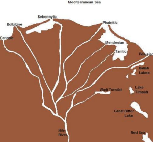
- The Nile delta historically had seven major arms: https://upload.wikimedia.org/wikipedia/commons/4/4e/Nile_Delta_Surrounding.jpg
- The North-South Suez canal did not exist, but a West-East pharaonic canal (dug by Necho II, Darius, Ptolemy II, Trajan, or someone else, depending on which source you prefer) connected the Nile with the Red Sea.
- The Nile valley is great for agriculture, but lacking in other natural resources. Mineral mines and stone quarries were located in the mountains beyond the eastern desert (e.g. towards the Red Sea coast). Wood was imported from the Lebanon.
I honestly wouldn't feel comfortable ignoring your remarks. In contrast, as I totally agree with you. The question is, what can we possibly implement within the boundaries of the game mechanics and map size.
E.g. the Persian base on Sinai is just there to provide diversity. If we had the possibility to create a map twice as big, it could be extended to include the Zagros mountains. Then the Persians could be used to represent the Parthians and the Seleucids could cover the area of Syria. I think there are two main problems with even bigger maps. The game, I believe it is the pathfinder, has troubles handling such large maps. It already struggles with the map size "giant" when you add more than four players. The second problem is that you would need to limit building to fertile areas or areas that are otherwise suitable: Otherwise you wold see huge deserts covered in civil centers and farms. I think a solution to this problem is currently out of reach. It it was possible it would shift the gameplay a little from tactical to strategic, as the time spent traveling on long distance routes and reconnaissance becomes crucial.
The reason I reduced the Nile delta to two navigable arms only is again map size. The arms are thinner than the main river. The width of the main river was chosen as small as possible, but it had to big enough to allow two ships of the biggest ship class pass by each other. The arms therefore can't handle that sort of ship traffic. As a consequence I created two major arms. If I dug an East-West canal this means there were three navigable rivers in the delta. I am thinking about a way to place them without creating too much additional water surface. It would look odd if there was more water than land in the delta. Any suggestions?
Indeed the wood of date palms is not comparable in quality to that of the cypresses of Lebanon. Sure, you could create palms with less value in wood, but than you would has to introduce some kind of trade function for wood from external places or something like that. Do you have any idea on how to implement such a feature?
Greetings
mimesot -
10 minutes ago, bb_ said:
Based on the screenshots, the map looks pretty good already (however I am not a good judge in these matters), but I think you forgot to attach the map files, so none can download the map
 .
.
Regarding the capture issue in the current svn (development version) there is an "uncapturable" flag, which might solve what you are after.
Thanks for the hint. I would really love to be able to insert specific tags into the map-xml file, in order to affect just the specific item I want to manipulate. This would be much easier than to create a separate entity file for each modified enity class. Currenlty thhe xml can only store xy coordinates and orientation, right?
9 minutes ago, Loki1950 said:Nice but you did not actually attach the files for download at all
 it takes awhile to get use to the forum software
Enjoy the Choice
")
You were just faster reading than me inserting all that stuff ;-)
-
 1
1
-
-
- Popular Post
- Popular Post
Update of map post alpha 23 (version 1.0.7 in the download section)
---------------------------------------------------------------------------------------------------Hi everyone!
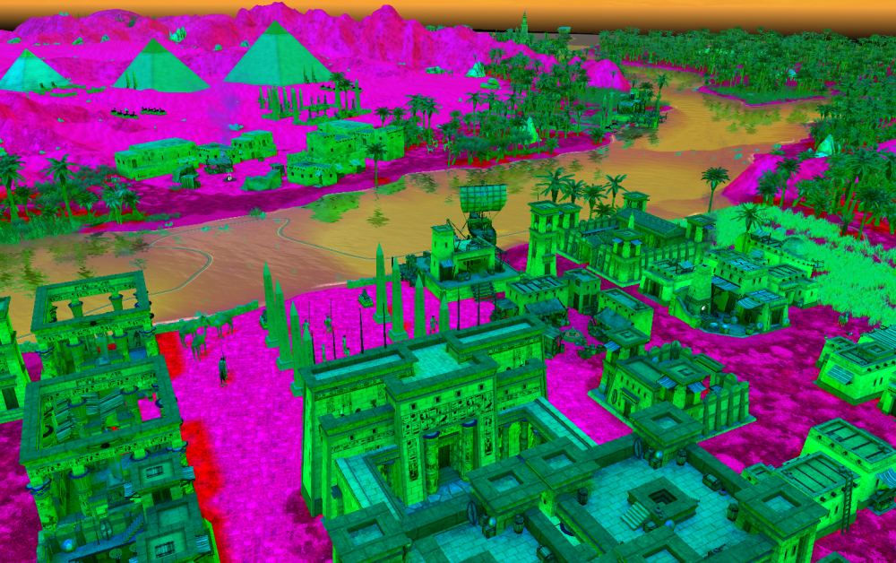
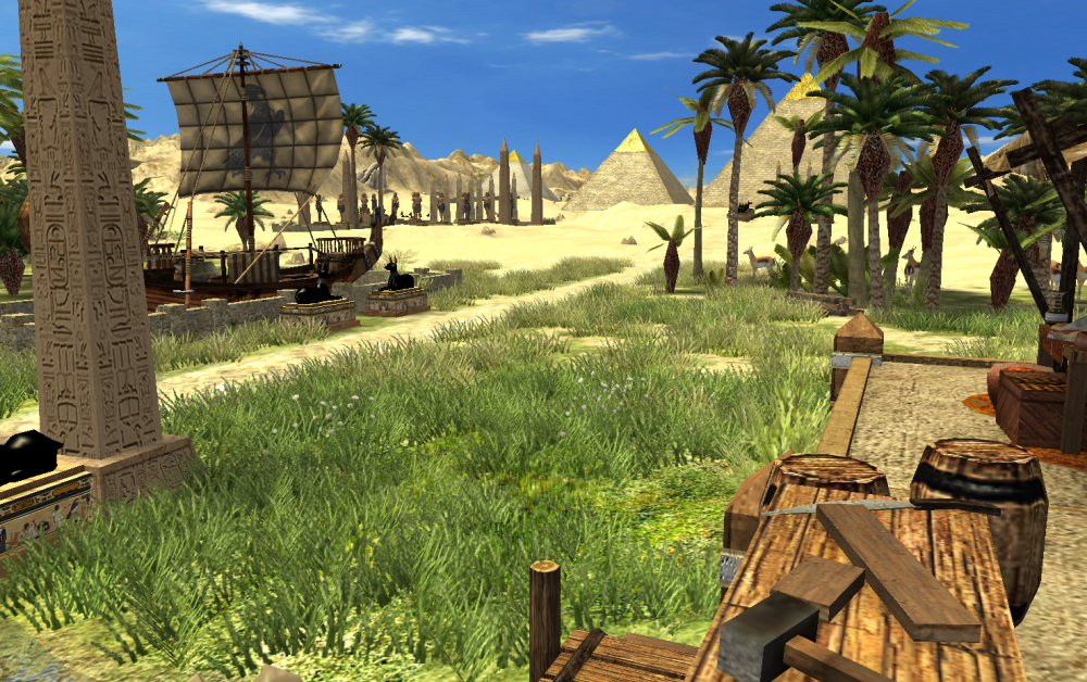
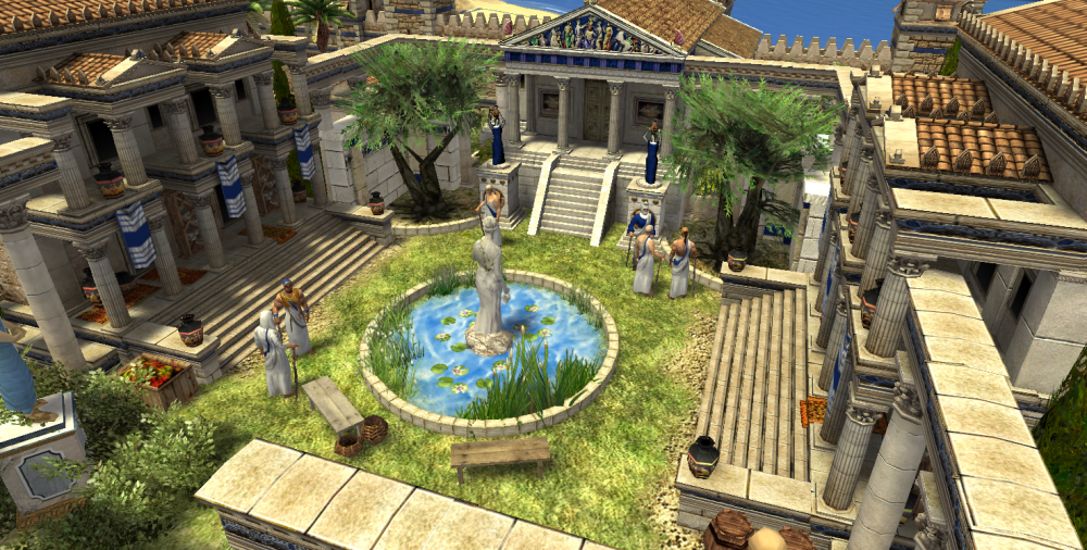
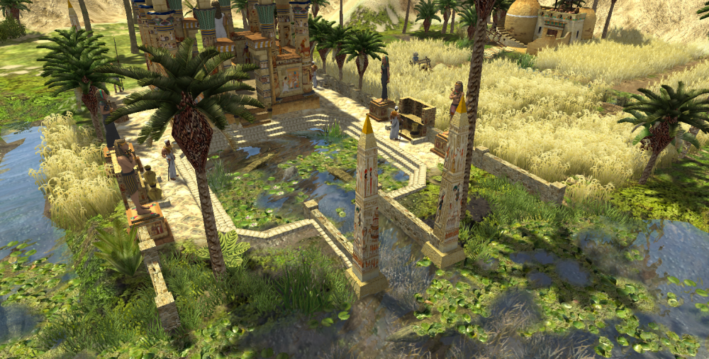
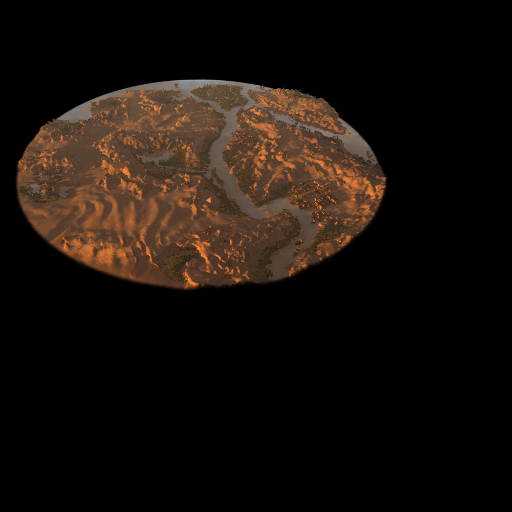
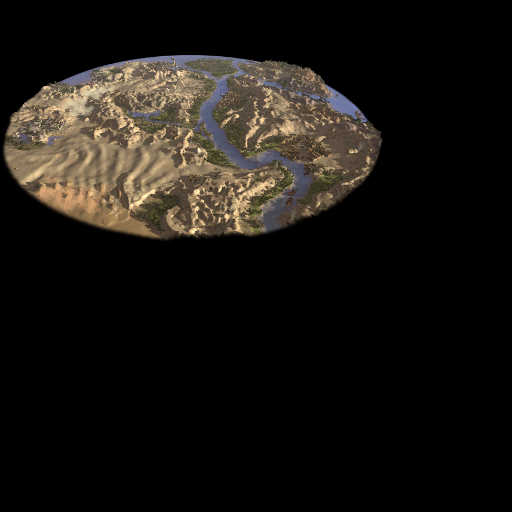
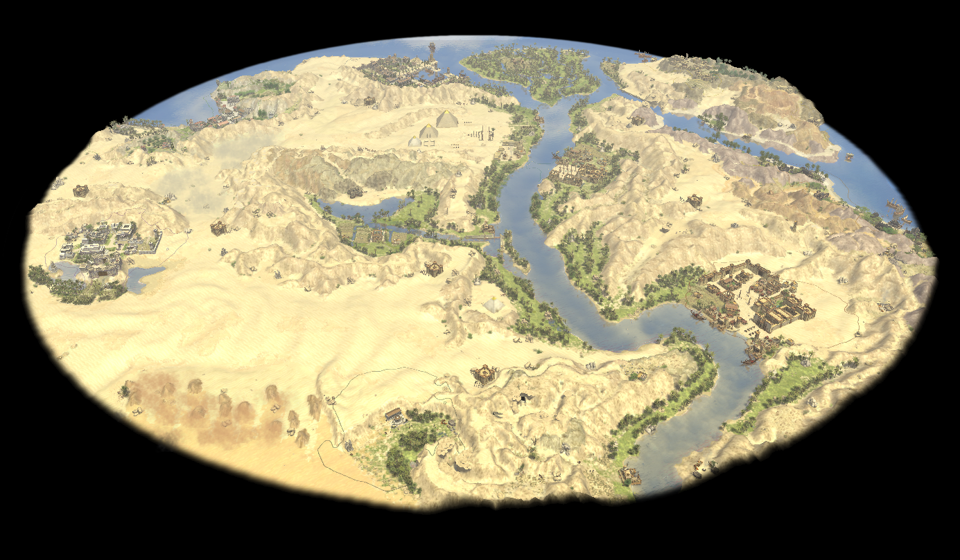
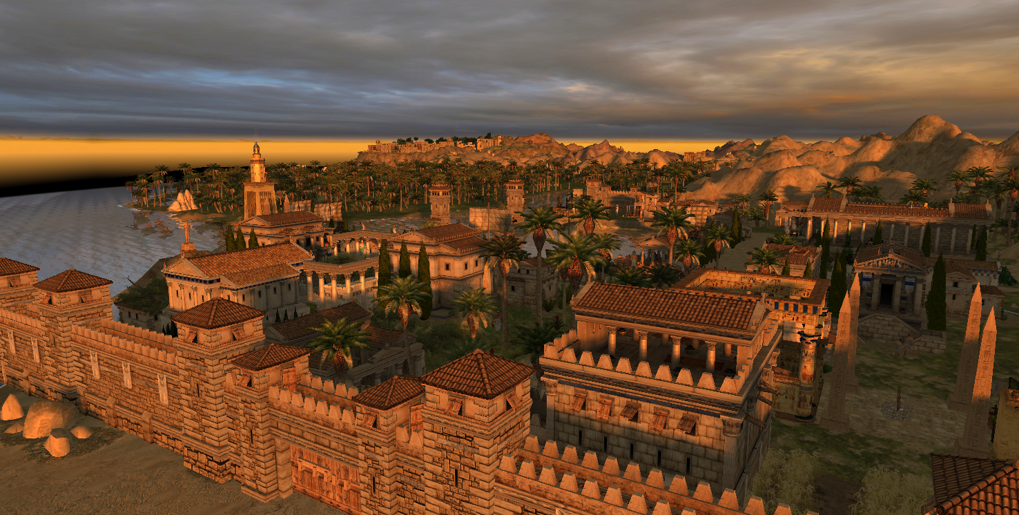
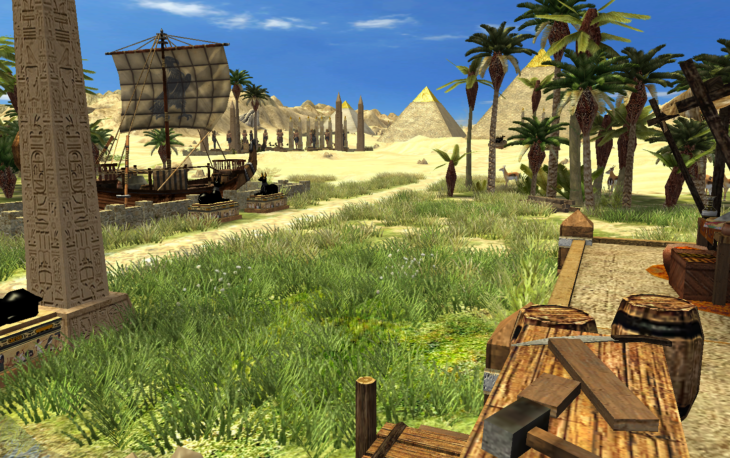
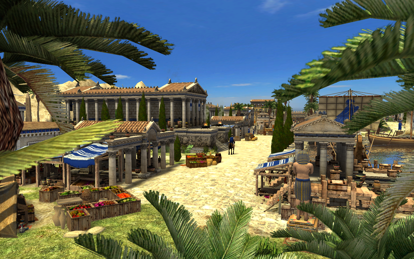
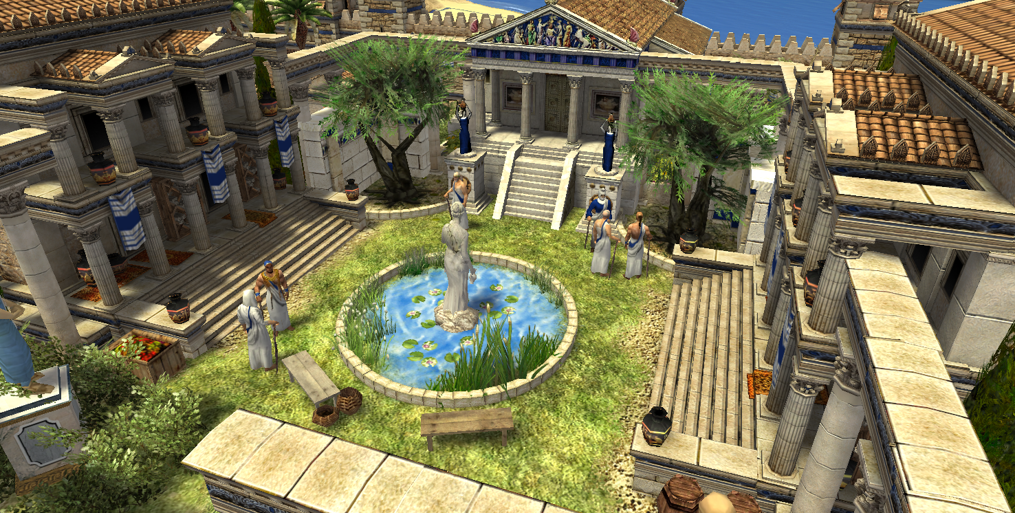
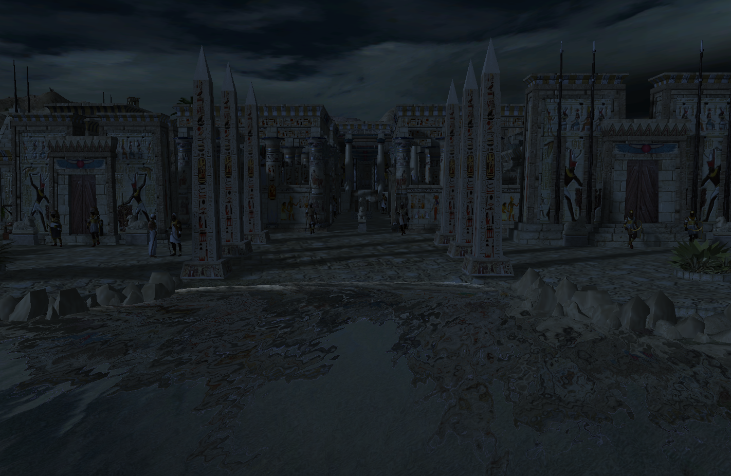
I wanted to share my first 0 A.D. map - well, rather a preliminary version - with you. I was inspired by the map of Assassins Creed Origins which just crammed everything Egypt into a single place, often disregarding realism in favor of aesthetics and gameplay, which I did as well. I did for example borrow the idea of moving Cyrene, which is around 700km to the west into Alexandrias vicinity in order to add some Mediterranean environment. A further reason for me to pick that setting was that it allows me to have a lot of different cultures on the map. The upper Nile area is dominated by ptolemaic retro-egypt buildings, whereas the city of Alexandria is dominated by hellenic influences. Cyrene gave me an excuse for adding the Romans with some greek buildings, while I put the Persians, who were admittedly not really present at that same time, in the east. For purely aesthetic reasons I let Carthage occupy the Siwa oasis, and the Red Sea became a tourist destination for Mauryan coral reef divers.

Map variants
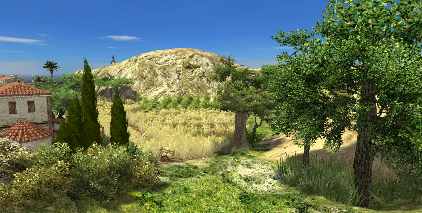
First of all, please take note, that this is not a final product, not even close. The map already includes most of the geological features and special locations I intended to add, but there are many areas that severely lack in detail, which is quite ok for sand deserts, but looks odd in places like coasts, riverbanks and rocky deserts. Blocking the map is also an issue, mainly because it feels strange, when the AI builds farms in the middle of the desert. The greatest thing that needs to be taken care of is balancing.
Basic properties
- Type: skirmish
- Map size: giant
- Players: 6
- Game version: alpha 23 (re-release)
Right now (8.2.2018) I will only publish a 1 vs. 1 map. This has the benefit of being at least a little easier to balance out. I will provide
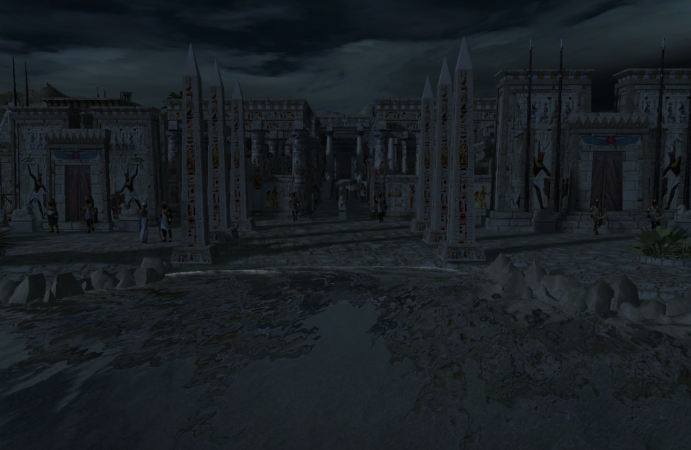
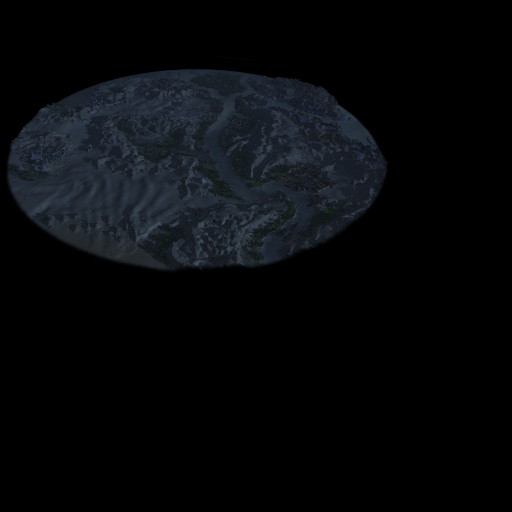
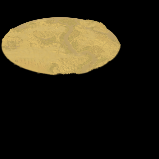
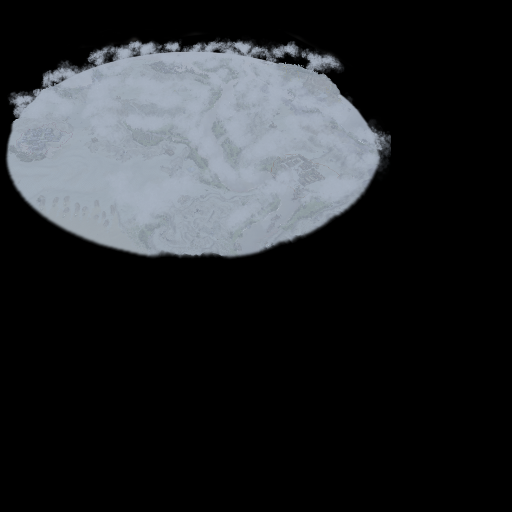
- A regular day version
- And a full-moon night version, because it looks just darn beautiful.
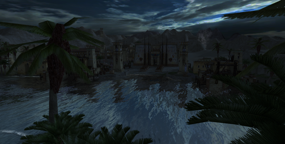
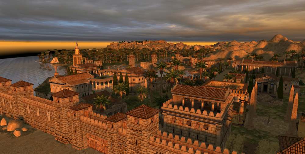
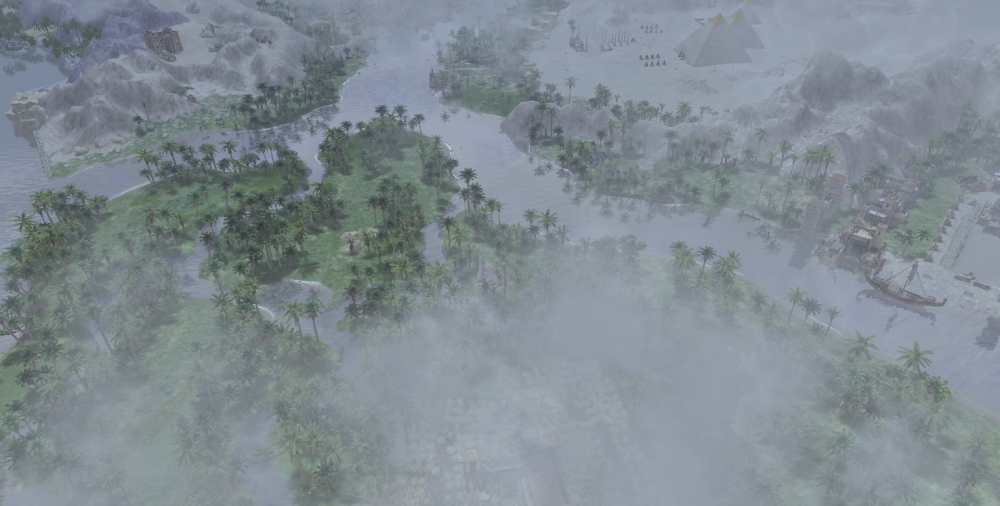
I really love what you can do with the lighting and ambient conditions ...
Spoilerlike sunset
or rainy days
or a desert storm
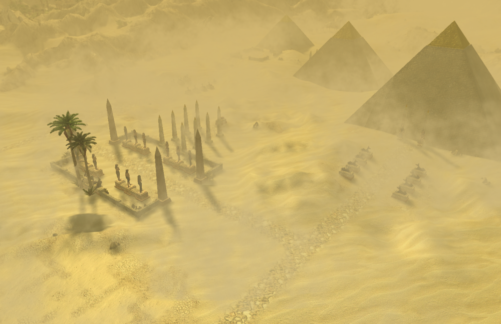
or pharaoes on ...
Update march 2018: A 3 vs. 3 map variant is now available and several small fixes regarding terrain, blockings and balancing have been made.
On the long term I will try to release two varieties of the map regarding gameplay
- An all-in map: This one is outfitted with full grown cities and you will start with huge amounts of resources and a sizable army. Don’t try to play this with 7 AI players, as it will probably lag horribly.
-
A stripped down version: Everything, except for the most prominent points of interest (e.g. the library) will be deleted. The difficult thing about this is that I will need to create a mod in order to achieve what I desire: See, if I make these buildings actors, all units will just pass through it, and if I leave them as entities, they will be taken over by the players within a few seconds and this would severely unbalance the game. Thus, I need to create a mod, which has all these buildings in a special version. I will increase those buildings capture points by a huge amount and also make them invulnerable, such that capturing them remains the only option. In some cases I might also try to reduce their functionality.
Thanks to all the guys who helped me with useful tips and insights regarding modding.
Gameplay
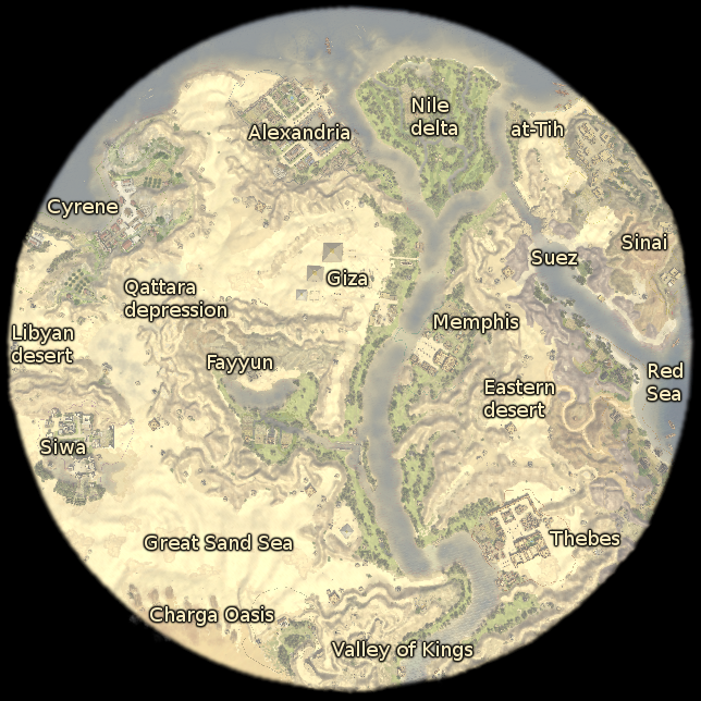
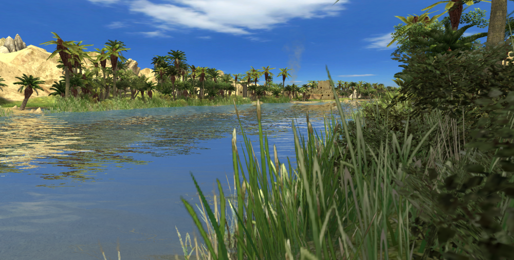
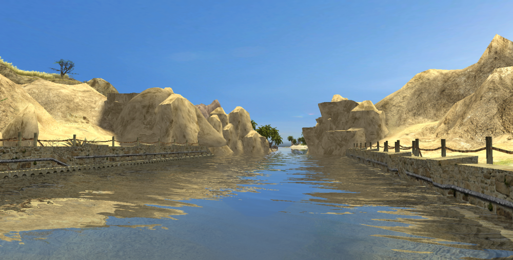
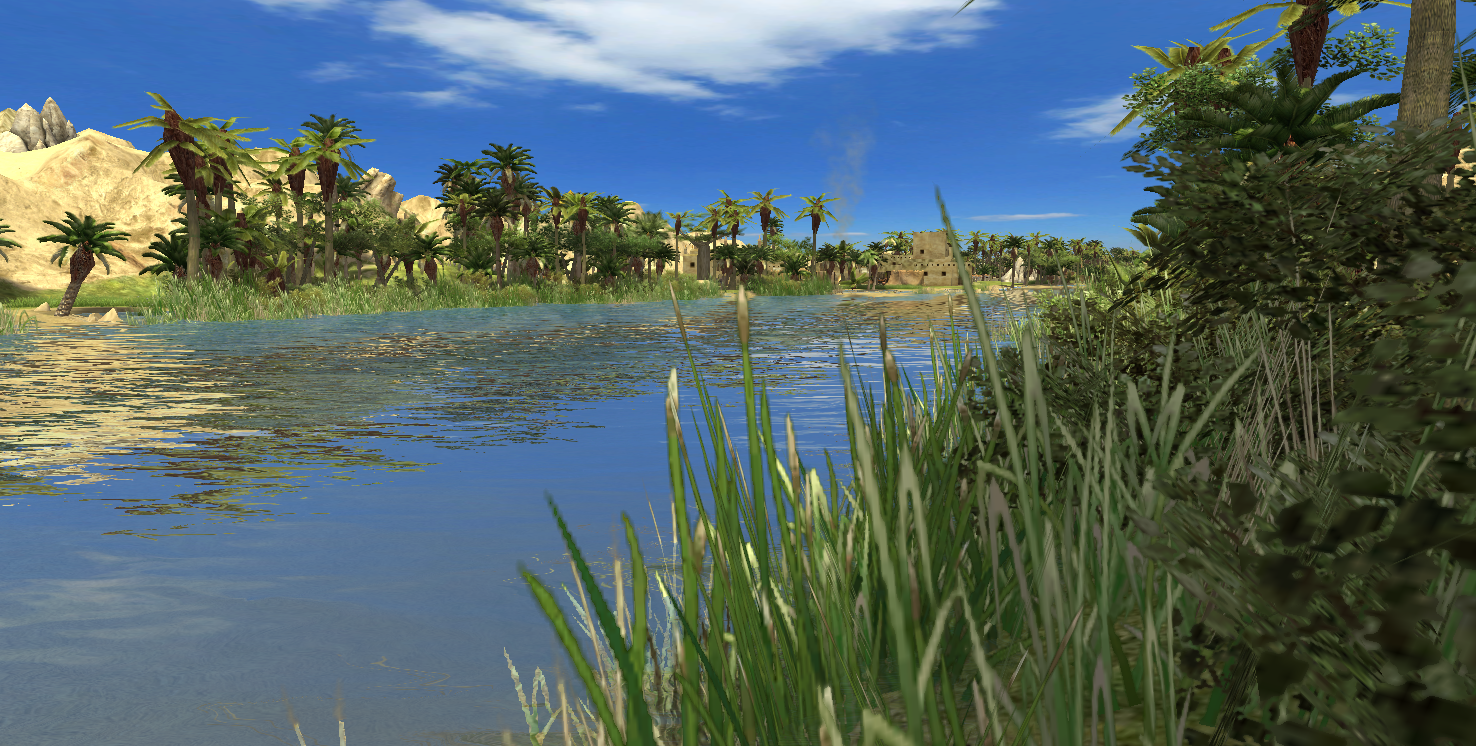
In this map I tried to elongate the distance between neighboring players and create straight routes between the distant ones. In order to achieve the first requirement, the rare shallow banks of river Nile, meandering mountain tracks and marauding packs of soldiers prohibit straightforward shifts of large armies. On the other hand far away players can often be reached via wide patches of desert, which act like highways on this map. One major problem was the city of Memphis, which is located almost in the center of the map. I order to provide this city with a slight chance for survival I shaped the eastern and western desert like a bypass circumventing Memphis and relocated the city to the eastern shore of the river Nile, which I made impassable from north to south, while only the western riverbanks remained open. The Mediterranean Sea and the river Nile are navigable, which serves as much better means of transportation than the walk along the river by foot.
Every player has wood in close vicinity to the starting point. No player will run out of wood easily. The banks of river Nile are especially rich in palms for obvious reasons. Stone is predominantly located in mountainous regions. Limestone can be found close to the pyramids and there is a rather large granite quarry in the very south. As I wanted the player to travel through the sandy dunes a lot metal can be found on the borders of sandy deserts. If you play the map, please let me know where you found too much resources and where they are missing.
Players & Matches
(and faction recommendations, mostly for esthetic reasons)
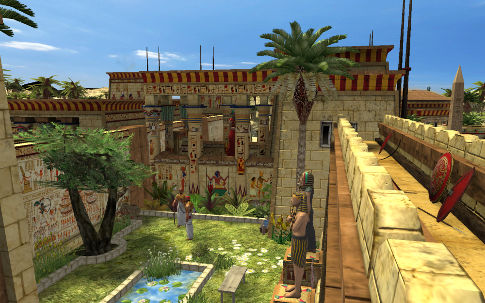
Currently (9.3.2018) only the six players are available.- Player #1: Alexandria (with greek and ptolemeaic entities) in the center north as Seleucids
- Player #2: Thebes in the very south as Kush
- Player #3: Siwa/Charga Oasis in the west as Carthage
- Player #4: Sinai in the north east as Persia
- Player #5: Memphis in the center as Ptolemeis
- Player #6: Cyrene in the north west as Romans
-
Player #7: Red Sea in the east as Mauryan (buildings might be reverted to random later) -
Player #8: Desert nomads from the south west (random)
Note: The AI does not get along with that map too well. It will soon be very crowded and very laggy if you choose a game with too many players.
Proper matches would be:
-
2 players: Lower Egypt (#1 Alexandria) vs. upper Egypt (#2 Thebes)
Lower Egypt currently has the edge, due to access to the Nile delta. - 3 players: Lower Egypt (#1 Alexandria) vs. upper Egypt (#2 Thebes) vs. Siwa (#3)
-
4 players: Egypt (#1 and #2) vs invaders (#3 Siwa and #4 Sinai)
Slowly approaches being balanced (version 0.19.10) -
6 players: Egypt (#1, #2, #5) vs invaders (#3, #4, #6)
Slowly approaches being balanced (version 0.20.7)
Points of interest (selection)
- Alexandria: library, harbor, lighthouse
- Memphis: necropolis, pyramids, Apis sanctuary
- Fayyum: Crocodile sanctuary, Bahr Yussef channel & dam
- Thebes: Temple district, valley of kings
- Western desert: Siwa oasis with fortress, Great sand sea, Quattara depression, guelta
- Eastern desert: Red Sea coral reefs, mount Sinai, "Suez channel", deep wadi
I collapsed some more screenies for you here ...
Spoiler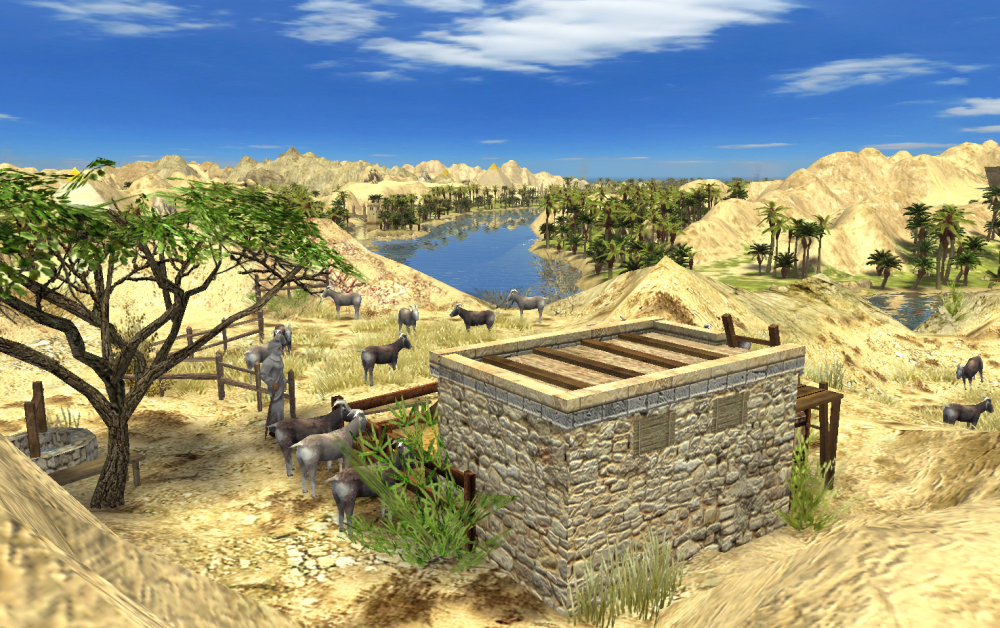


ToDo and Changelog
My ToDo-List is growing and shrinking all the time. If you have suggestions, please let me know. Unfortunately I cannot promise you, when or if I will implement them. You know, real life can be unpredictable ;-)SpoilerCurrent version: 0.19.6
Last editing date: 2018-02-08, Tasks...
-
Balancing with:
- starting resources,
- environmental resources,
- starting buildings,
- starting units,
- Gaia units obstructing paths, …
- Block terrain. In the meantime – as I do not want to start writing the mod yet – I will create a lot of small dunes, bulges and cliffs in order to prohibit the players, especially the AI to build civil centers and farms in absolutely inappropriate places.
- Embellish the rocky desert and the Nile delta with decorative actors. Especially the great Wadi needs some care. The Mediterranean coast as well.
-
Add more fish! -
Create a lion cave. -
Create a qanat spring in the southernmost oasis. -
Add two small rivers and a shallow pond to the Nile delta -
Wadi is blocked close to the pond -
Distance southernmost shallow river passage has its closest route towards player #8 via the great sand sea and not through the valley of kings -
Put the Fayyun stairs back or the mountains more to the front. The stairs are too dominant. -
Let some more eagles (kawks) fly.They appear to have a fixed flight hight regarding the ground which is irritating when they fly over rugged landscape. - Make all limestone mountains look more like mesas. My Limestone ridges are much too round in most locations.
- Create square areas where the building of civil centers is intended. This is especially missing in close vicinity to the pyramids, where randomly built civil centers disrupt the view. Block critical areas using tiny ripples on the ground.
-
Mountains can be passed near Thebes (between wasi and thebes) -
Metal blocks valley of kings base -
Clear Area around persian suez dock. Blocking - Cut off the tropical island like eastern gulf of suez shore, should I?
-
Change fertile green areas such that civil centers can be built immediately. Trees are blocking the way - Intertwine the red and grey stones areas. I would love to have a slightly more yellowish and brighter and a slightly more reddish version of the Persian cliffs. Perhaps I can mod this as well.
- Populate the seabed, shores, riverbed and riverbanks with reeds and stones and additional textures.
- Create a mod with invincible buildings that have hugely high capture points and recreate points of interest with that. This will add balance and a resemblance to a domination game mode. Create objects that are blockers for building structures, but not prohibiting movement. Invisible (visible in atlas only) and invulnerable. Is it possible to create buildings that regularly spawn troops and sends them somewhere?
Lateste editing date: 15.2.2018, minor updates, cersion 0.19.9
-
Remove the prolemaic statue ruin entities and replace them with actors. They are less colorful but do not serve as stone mines.
- Alexandria
- others
-
Create blockers (ripples in the sand) in in deserts outside Alexandria and Siwa to prevent farms from bein built there
- Alexandria: North territory is not used any more
- Siwa: Less usage. TODO: Not completely done yet.
- Deep wadi in the eastern desert.
-
Correct location of the midgol strongholds. They are too aggressive in some locations. The AI always bumps into them and loses tons of females.
- Set them back regarding main routes
- Create cliffs to divert traffic
-
Gaia Units:
- Moved the starting Units of memphis slightly away from river nile. Too aggressive.
-
Use blockers (stone fence entity) around or beneath actors, such that units won't pass through them or build farms there.
- Old merchant, palace and government in Siwa
- Tent in the southern Fayyum mountains
- In front of the Alexandria egyptian temple
- Giza Necropolis
-
Units traversing mountains in undesired locations
- Suez west at canyon
- Cyrene plateau south
- Ridge behind hiza pyramids
- Goats appeared in the mountains around the valley of kings
-
Units (elephants) get stuck in small passages
- Deep wadi
- Persian base and middle sinai path
- Thebes to eastern desert
-
Eyecandy
- Grass between olives in cyrene plateau
- Tent in the southern Fayyum mountains with a small treasure
- Riverbank eastern nile arm
- Apis shrine improved usind the iberian monument
- TODO Create a multi-level farm in the delta e.g. date palm farm with lower trees in the shadow beneath and goats or crops on the ground. Delta looks so unpopulated. Road through the delta? Create a miniature botanical desert plant garden?
-
Terrain
- Lowered ridge between cyrene plateau and town for a better view
- Made Mount Sinai the highert location on the map
-
Replace some tree entities in the cities with actors in case they should not be chopped down
- Alexandria alleys and cypresses
-
Guide the AI to develope in specific directions
- Alexandia and Siwa: Added a metal mine in a non-lethal location.
- Addred a storehouse near Siwas most relevant wood.
-
Unknown behavious:
- TODO: Why are the ships of the AI playing Alexandria always trying reach to the upper harbor tower. They can fit through the entrance of the harbour.
-
Balancing:
- Relocated many metal and stonemines: Needs TESTING
- Buffed Sinais and Siwas starting units.
- Create wider shallow river banks to reduce the amount of collisions with ships.
Lateste editing date: 18.2.2018, minor updates, version 0.19.10
-
Unit paths:
- Closed a path, where you can enter Cyreneover the southern montain ridge
- Closed a path north of Thebes, where you could run parallel to the desert in the mountains
-
AI trouble:
- Moved the Migdol castle east of Siwa, as Siwa always wanted to build a farm in range of the castles arrows.
- More blockings in Giza to prevent fields and barracks to be built over anubis statues.
-
Gameplay
- Moved one Migdol castle in the north of giza desert to the south border of the desert in order to prevent early trade routes
- Created one castle in the desert corridor between Cyrene and Alexandria. There are now 7 gaia castles.
-
Eyecandy
- Altered all 7 gaia castles in order to make each one unique.
-
Other small flaws
- There were some roman statues around which are mined for stone
Lateste editing date: 26.2.2018, update to match alpha 23, version 0.20.2
- Replaced all alpha 22 entities with alpha 23 pendants
- Relocated the Thebes temple and yard to Memphis and created a Kush settlement in Thebes. Recreated Memphis from scratch.
- Built a small stairway bordered with desert plants (execandy)
- TODO: Check for troubles with the Kush harbor (very small)
- Siwa, closest castle in the east: Gaia soldiers are still too close and to much in the north regarding the castle.
- Thebes: Some fields were Gaia
- General problem: The preset colors (set in the map editor) are neither shown in the menu nor used ingame. Is this only functional for scenarions, but not for skirmishes?
- Siwa: the temple like building (Tophet) between the government center and small temple has been lost.
- Siwa: AI builds a farm on the center place. Flaced a fence.
- One can walk over the grey Mountain west of the suez channel. Steepened land
- One can get stuck with an elephant in Memphis in between market and barracks in the south. TEST
- Increase elevation of the Thebes land. Especially the quai. Looks silly. PARTIALLY DONE
- You can pass over the mountain ridge north of the cyrene olive plateau. Steepened land.
- Goats are invading mountains near valley of kings. Same.
- Antilopae on the small mountain south of Memphis. Same.
- The small place behind the Alexandria civil center needs some beautiful details. Currently it looks boring. Done.
- Siwa: There is a problem with elephants leaving the castle through the gates. Moved the castle. TEST
- Alexandria: Women are locked in behind the military colony. Done
Edited: 9.3.2018, update to match alpha 23, version 0.20.7
- Place for storehouse at primary metal mine in south of alexandria too narrow. Done
- Cyrene builds farm on the central mountain top. Made cliffs
- Charga civil center automatically took over fortress. Moved it to the south.
- Persian houses on the west side of the city build females to the back side, where they are stuck. TEST
- Persian has a muich too weak economy at start. Added females to match other cities
- Memphis is attacked like hell. Added a small army better suited for defense
- Added a route through the red sea via a shallow sea bed, so Persia can exmand more easily.
- Added some eyecandy to the nile delta.
Latest edit date: 30.12.2018, update 1.0.7
- coral reefs in the red sea, created a "sunken ship"
- secret garden at the side of the river nile
- "miles" of riverbanks are now covered in vegetation
- forests became a lot denser in some specific spots (esp. covering the view from the nile delta onto the main river branches
- repaired street textures
- fences are now surrounding the persian cliff base
- theres an additional shalow crossing of the red sea now
- decorated the mauryan temple
- minor aesthetical details
ToDo:
- Creat some white desert elements.
- There is a skirmish/units/default_infantry_melee_b in Alexandria central between wonder and port that causes trouble when set to gaia
Download
Download the files and put them into the specific folders for maps and preview images. The paths I will state below are default paths for typical Windows 10 installation but may vary depending on your system and installation path. In case subfolders do not exist yet on your system, simply create them.
Map files:
Download:
- Version 0.19.6 (1 vs. 1)
- Version 0.19.10 (currrent)
-
Spoiler
- master file (8 players, day, not recommended for playing)
- day (4 players)
-
night
- egypt_condensed_mimesot_v0_19_10a_2vs2_night.xml
- take the *_day.pmp file and exchange day for night.
-
sunset
- egypt_condensed_mimesot_v0_19_10a_2vs2_sunset.xml
- take the *_day.pmp file and exchange day for sunset.
-
duststorm
- egypt_condensed_mimesot_v0_19_10a_2vs2_duststorm.xml
- take the *_day.pmp file and exchange day for duststorm.
-
rainy
- egypt_condensed_mimesot_v0_19_10a_2vs2_rainy.xml
- take the *_day.pmp file and exchange day for rainy.
-
morning
- egypt_condensed_mimesot_v0_19_10a_2vs2_morning.xml
- take the *_day.pmp file and exchange day for morning.
- 7zip packages with all files (kompressed to 650kB)
-
Version 0.20.7 (for upcoming release alpha23, new route through the red sea for balancing)
Spoiler
- master file (8 players, day, not recommended for playing)
-
3vs3, day
- egypt_condensed_mimesot_v0_20_7a_3vs3_day.xml
- take the *_alpha23.pmp file and exchange "_alpha23" "a_3vs3_day"
-
3vs3, night
- egypt_condensed_mimesot_v0_20_7a_3vs3_night.xml
- take the *_alpha23.pmp file and exchange "_alpha23" "a_3vs3_night"
- other environment settings will follow in the next few days
-
Version 1.0.7 (30.12.2018, based on published version of 0 A.D. version alpha 23, design enhancments: red sea riffs, more nile river bank vegetation, parapets for persian base, fire places for town centers, small secret garden, other small fixes like missing ground textures, etc.)
Spoiler
- 3vs3, day: Egypt_1_0_7.zip
Path: “C:\users\yourname\documents\my games\0ad\mods\user\maps\skirmishes”
When is the good time for deleting older versions from a post?
Can I make the XML files all use the same PMP file?
I noticed a zipped xml is about 10 times smaller. is the community OK with zip files?Map preview images:
Download:
Spoiler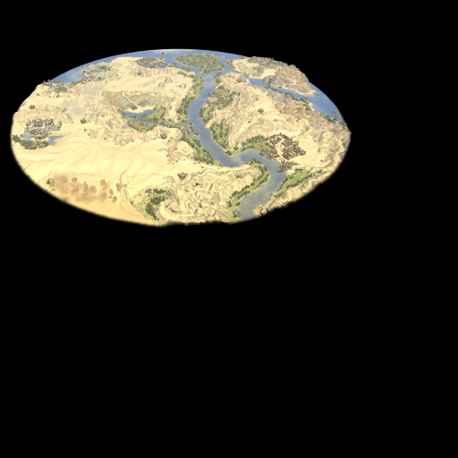
Path: “C:\users\yourname\appdata\local\0 A.D. alpha\binaries\data\mods\public\art\textures\ui\session\icons\mappreview”
In case you are playing this map, please let me know about anything that can be optimized. Thanks a lot in advance.
Greetings
mimesot-
18
-
 4
4
-
Hi there!
You guys are awsome :-)
@Skhorn
22 hours ago, Skhorn said:This might help you https://trac.wildfiregames.com/wiki/Modding_Guide
Indeed, thanks for the suggestion! I would like to ask you further, if there is any comprehensive list of the XML-tags. I opened quite a lot XMLs yesterday but i didn't stuble across the one, which wowgetoffyourcellphone came up with ... like pulling a rabbit out of a hat.
<VisibleInAtlasOnly>true</VisibleInAtlasOnly>
22 hours ago, Skhorn said:Beware, that if you want to share your map, you gotta share those files too.
It is always good to be reminded of possible pitfalls. Is there an elegant way to do so? As the root folder of 0 a.d. appears not to have a fixed relative path regarding the maps folder I cannot simply create a self-extractinng zip. How does the game remain consistent among different players? By just adding files, not modifying existing ones, does this alter the game in a way it becomes impossible to start multiplayer games? I would have to place a big warning sign on my map then.
@wowgetoffyourcellphone
19 hours ago, wowgetoffyourcellphone said:You could copy the code from this and then make the obstruction whatever size you want and the Atlas-only visible actor whatever you want.
This is a great template. I will incorporate it. Thanks a lot.
@stanislas69
16 hours ago, stanislas69 said:You can render a unit invulnerable by setting a flag in the templates
By "a flag" do you actually mean something like
<invulnerable/>-
1
-
-
Hi!
Thanks for the fast response.
Wow, I really like that game as a game, but now I am absolutly amazed how every thing about these entities (except for meshes and such) is human readable and tidily hierarchically structured. (OK, right now I am asking myself why they mixed xml and json). You just need to know that the entity file inherits every property from its parent and you can just overwrite one, including the actor for the visual representation. I just created an indestructable, uncapturable seleukidian library with the looks of a the macedonian library. This is really awsome.
Is there a way to remove the health but keep the option to capture it?
And in case I want an object, which is impossible to capture: Is there a Way to remove the capture points bar?
I realized that there is a parameter looking like this, which I can possibly use to place a special stone in the desert/mountains which blockss alll building.
  <Obstruction>
    <Active>true</Active>
    <BlockMovement>false</BlockMovement>
    <BlockPathfinding>false</BlockPathfinding>
    <BlockFoundation>true</BlockFoundation>
    <BlockConstruction>true</BlockConstruction>
    <DisableBlockMovement>false</DisableBlockMovement>
    <DisableBlockPathfinding>false</DisableBlockPathfinding>
    <Static width="100.0" depth="100.0"/>
  </Obstruction>
I will try that tomorrow.
Thanls again and good night!
mimesot
-
Hi!
I am currently having a lot of fun with the 0 A.D. map editor.
One thing I noticed, when placing objects was that I can move my units through all actors. Only entities are blocking the path. If I have a desert stonnemine, these large chunks of rock can only be placed as actors, all units are moving through. I could place a stationary entity object right beneath it to block the path, but then that entity object would be a gaia object, which you can either mine or destroy, which thus does not reslove the problem. Is there any way to have e.g. blocking actor or to define an entity as indestuctable or to have a dummy object, flat and small enough to hide it beneath rocks and gaia-buildings?
The second question is wether there is a way to make terrain, which is flat but still not usable for building something upon it. Like when creating a lava lake. I especially would like to prohibit farms on desert and rocks.
Thanks and kind regards
mimesot
-
Hi!
That trick, adding a pathOn 7.1.2018 at 5:43 PM, elexis said:binaries/data/mods/public/art/textures/ui/session/icons/mappreview
like this added a map preview for me. But what is the necessary resolution for the image. My preview appears too large and stretched as well.
Kind regards and thanks
mimesot
EDIT: I looked into the public.zip in binaries/data/mod/public and found the previews there to be 512x512px with the actual mappreview occupying roughly 400x300px in the upper left corner. I rezized a screeny accordingly and added the black space. What is this black space for? Anyway, it worked out perfectly.
-
1
-


Skirmish map - Egypt (previously "Egypt condensed")
in Scenario Design/Map making
Posted · Edited by mimesot
In case that happens ... just a console error but no visual representation any more ...
Assume you removed the Ptolemaic wonder. Could I simply search my maps XML for the phrase "structures/ptol_wonder" and delete that entity section and it will be fine? Is a missing entity uid of any concern?
One further question. If I have an actor that has multiple visual representations that occur with specific frequencies when you place them (like it is the case with various stones and grass patches), how does the map file "remember", which one was chosen. I can't see my map pick a random kind of e.g. short cretan date palm each time I load it, fortunately.
Sorry, but I have a third question. It is an issue with my map, which you can see in some of my screenshots, but I think this can lead to a feature request if feasible. You surely noticed the black horizon on most flat angle screenshots, which is not very pleasing. I guess this this originates from some kind of compromise. The skybox is needed to create, well, a sky and the beautiful reflections on the water. On the other hand there is the equally beautiful circular map shape with its smooth transition into blackness, which you usually look upon from above. What if the transition wasn't into blackness but into transparency and the skybox had a much lower lower boundary. As the botton of the skybox is black, you wouldn't see any difference at the transition zone when looking down at a steep angle. At a flat angle the transition zone would look much slimmer (except the terrain was inclined steep upwards) and transition from terrain texture to sky texture. If the terrain at the map boundary was sloped downwards you would even get a hard horizon line. Is this possible? Does the engine support alpha values for terrain surfaces?